


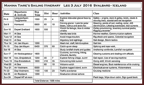
John and Amanda Neal, aboard their Hallberg Rassy 46, Mahina Tiare, take their expedition crew on a true high latitude adventure on the 1,500-mile cruise from Norway’s Spitsbergen Island to the island nation of Iceland (published May 2017)
July 11, 2016, 1400 hrs, 75.26 N, 03.12 E, Log: 195,381 miles Baro: 1010.1, Cabin Temp: 63 F (with a furnace on), Cockpit: 50 F, Sea Water: 45.7F Broad reaching at 6.5 – 7.5 kts with 17-20 kt NW winds, no reefs, whisker pole set
GOODBYE TO AN OLD FRIEND
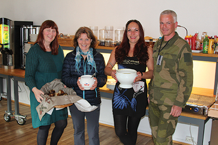
Our eight day turnaround between expeditions in Spitsbergen slipped by fast, but between boat projects Amanda and I found time for trail running around Longyearbyen and out to the Global Seed Vault (basically the only places one can run or hike without carrying a rifle). We also undertook visits to the extensive local artist galleries and the few small museums dedicated to the arctic and its exploration history plus hikes up the Longyear valley where we checked out the old coal miners’ accommodations and dining hall that is now a vintage hotel.
 Just when we’d planned the remaining five days of our turnaround strong northeast winds were forecast for our Longyearbyen anchorage. Knowing we were unlikely to stay put in the thick kelp bottom we searched the chart for an interesting and safer alternative and came up with Kapp Wijk, 22 miles away. Assuming we could anchor on a sandy glacial sill in moderate depths we set off downwind under headsail on a smooth and quiet sail under a cloudless sky. Upon arriving in the bay, we anchored a mile past three huts, four snow machines and two skiffs all located above the beach where a large wooden frame hung with seal meat stood. Seeing no signs of life over the next 24 hours we gathered it must be a fur trapper’s winter encampment.
The wind moderated a little the next day so we packed the rifle, flare gun, and PLB for a beach walk. We had two concerns; meeting a polar bear or having the rising tide float the dinghy away. The beach was pea gravel rendering our dinghy beaching wheels useless so we used driftwood as rollers and slid the dinghy as high as we could, wishing we’d brought our dinghy anchor for even more security. It turned out to be a further walk to the cabins than it looked and when we were nearly there, Amanda noticed a person walking between the huts.
When we arrived at the huts we met Harald; an old-time trapper who’d been in Svalbard for 39 years. He seemed a little shy, but when I asked him if he knew what time high tide was, he eagerly invited me inside, (Amanda was busy studying the nesting eider ducks surrounding Harald’s cabin), where he promptly turned on his computer, opened C-Map (the same electronic charts we use) from which he got the time of high tide. Harald had been a microbiologist in Bergen and at the age of 36 decided to try a winter season on Svalbard, trapping fox and living off the land. At the end of the winter he’d a million things he wanted to do so decided to stay on. From this base, he worked a 250 km long arctic fox trap area on sled and dog team that had three additional huts in different bays.
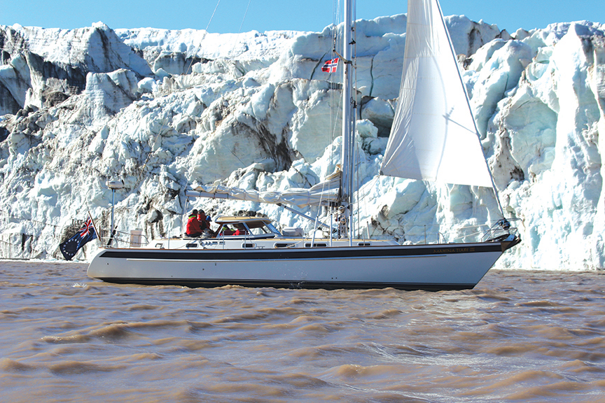
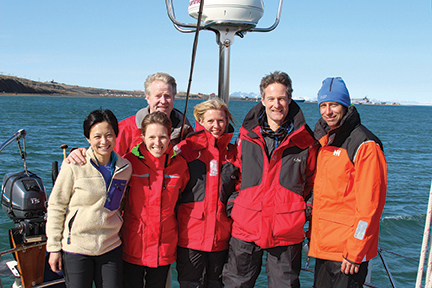 The next morning, in Longyearbyen, we returned our rented rifle and flare gun and completed our main grocery shop for the upcoming expedition. Our expedition crew joined us Friday, July 8th and following orientation we set sail for a secure anchorage in Bellsund, 70 miles to the south where a polar bear and her two cubs had recently been sighted. The new crew certainly took the cake in terms of eagerness for adventure as four out of six arrived in Spitsbergen up to a week early to enjoy adventures ashore before joining us. When we arrived in Fridtjovhamna, Bellsund it was 0030 Saturday and we anchored in the lee of a sandbar in 30 feet of very sticky mud with MT’s stern facing the impressive and actively calving tidewater Fridtjovbreen (Fridtjov glacier) two miles further in the bay. Before turning in we all had a good look for bears, from the cockpit, but saw no signs of movement.
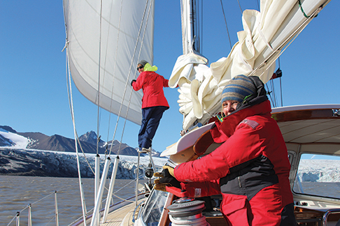
Sunday morning, we completed galley, engine room, safety, liferaft, Lifesling and harness orientation, enjoyed lunch and then set sail up to the face of the glacier. After cruising along the glacier in windy conditions, we headed five miles away in the lee of Akseløya Island enjoying expansive views of Bellsund and its several stunning tributaries. After dinner, we set our alarm clocks for an 0200 departure and before heading off to bed, I stood in the cockpit for some time, absorbing the wild and grand beauty of the surrounding glaciers and rugged mountains.
It was so bright at 0200 we all had to wear sunglasses as we raised anchor, hoisted and reefed sails, set the preventer and bore away for Jan Mayen, 550 miles to the southwest with 20-25 knots of wind and smooth seas. Many times Amanda and I looked back at Svalbard, wondering if and when we’ll return. Amanda talks about spending more time on our next visit and perhaps circumnavigating the entire archipelago since the eastern side is now mostly ice free. As it was Abby and Amanda’s watch, I headed back to bed, only to later learn that shortly after I’d crashed, they’d seen a blue whale blow numerous times. At up to 110 feet in length, they are the largest mammals in the world and two were recently sighted off Longyearbyen.
July 16, 2016, 0700 hrs, 66.34 N, 12.50 W, Log: 196,024 miles Baro: 1007.1, Cabin Temp: 62 F (with a furnace on), Cockpit: 44 F, Sea Water: 50.0F (Gulf Stream influenced, no doubt!) Broad reaching at 7 kts in 20 kt ENE winds under double reefed main and genoa
PITSTOP AT JAN MAYEN
 For three days, we broad reached under full main and poled-out genoa without once touching the sheets or reefing, in brilliant 24 hours a day sunshine to start with, but with increasing bands of fog as we approached Jan Mayen. Our first view of Jan Mayen was of tall cliffs shrouded in fog but then the fog lifted and we had an amazing sunny view of the 6,000-foot tall glacier-clad volcano Beerenberg.
As we sailed along Jan Mayen’s impressive cliffs, glaciers and waterfalls, we spotted one small trappers hut then the dirt airstrip, along with LORAN and radio towers as we approached the main meteorological station located two-thirds of the way down the island. I hadn’t received a reply to the emailed request for permission to visit I’d sent to the Norwegian base commander but once I contacted Jan Mayen Radio on VHF, I was able to speak directly with him. He approved our stopping for a maximum 24 hours and said he’d meet us on the beach just south of the station.
Batvika, the only approved anchorage on Jan Mayen’s south coast, is an open roadstead but wasn’t too rolly and the anchor felt like it set securely. In no time flat, we’d launched the RIB and headed ashore, uncertain if we’d be able to land our first group through the swell. The beach was gorgeous black volcanic sand that dropped off quickly allowing me to unload crew over the bow before quickly backing out of the surf line to fetch the second group.
The station commander, Lt. Col. Rune Leirvik, a handsome Norwegian air force officer, helped us carry our RIB up the beach and then filled us in on Jan Mayen’s colorful history as we walked the short distance to the Norwegian station. Rune is a climber and skier and a couple years ago he’d skied across Greenland with a group of friends. He’d only arrived for his one-year posting in March and by June he’d summited Mt. Beerenberg with five of his base staff in a massive 22-hour effort.
 Wednesday and Saturday nights are “social pub nights” at the station and most of the 18 staff were enjoying libations when we arrived. Rune had Ellen, the nurse, open the shop which sells souvenirs, postcards, chocolate and warm clothes. We were then introduced to Elisabeth, the assistant chef, who served us homemade bread and excellent soup during which our crew enjoyed chatting with a few of the base members, learning of their six-month job rotations. We asked the head chef if they were short of food supplies and she shyly mentioned they had run out of tomatoes and fruit so we promised to bring some in the morning. Returning to the beach where we’d left our RIB, we were grateful to see MT calmly at anchor and easily got everyone back aboard. It was 2330 but with tranquil conditions Sean and Donnie dove in for a swim and we all enjoyed chocolate and tea, celebrating our safe arrival.
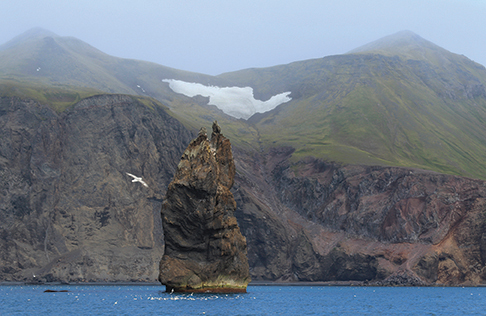
The base commander had asked that I return with our passports the following morning, so after breakfast we headed ashore. The crew took off on runs and hikes while Amanda and I chatted with Rune. He’d mentioned that the weather on Jan Mayen is constantly changing—what might be a protected anchorage one moment could become a dangerous lee shore the next and by the time we got back to MT the winds were gusting to 30 knots making it temporarily impossible to retrieve the motor and RIB. Thankfully once we were ready to depart a temporary lull in the wind speed occurred and we could quickly winch the motor, then the RIB on deck. After raising anchor, we sailed south along the coast and close by Fyrtamet Rock, a 150-foot tall, dramatic sea stack before setting a course for Iceland.
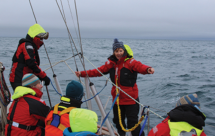
A slow-moving low pressure cell had given us great sailing with 30 to 34 knots on the beam and now broad reaching conditions. As the low moved slowly towards Norway our wind backed so what started out as a close reach was now a broad reach. This allowed us to take the breaking seas on the quarter, giving us some good bursts of surfing speed. During orientation, several of our crew specifically mentioned they were interested in gaining heavy weather experience so they enjoyed these conditions, which were forecast to moderate that afternoon. We were all excited about landfall sometime after dinner that night and everyone had been busy reading up about Iceland’s east coast.
July 16, 2019, 1500 hrs, 66.34 N, 12.50 W, Log: 196,024 miles Baro: 1007.1, Cabin Temp: 60 F (no furnace on, hooray!), Cockpit: 66 F, Sea Water: 50.0F
ON TO ICELAND
 We had an easy arrival at Seydisfjordur, Iceland, and a Polish training yacht that we’d followed up the fjord was just completing clearing customs so we tied ahead of them. Even before we’d completed adjusting fenders and lines I welcomed the very friendly customs officer aboard. He said he is always on call (it was a Saturday night) and there was no charge for customs. The harbormaster stopped by briefly, but when we mentioned we hadn’t been able to purchase any Icelandic kroner, he said he wasn’t set up for credit cards so, “Don’t worry about paying”.
We arrived during an annual festival that celebrates creativity, art and culture and several thousand very colorful young festival goers were catching busses to the nearby concert and festival venues from campsites scattered around the fjord. With a resident population of 650, it didn’t take long to locate the one small supermarket and gas station and after a short walk around the charming town we all slept like the dead that night and never heard Peter Smith, (inventor of the Rocna Anchor) aboard Kiwi Roa moor directly in front of us.
The next morning Amanda and I visited the service station. It’s illegal to fill propane tanks in the EU and exchanging tanks is difficult as every country has different sized tanks and pipe threads. Fortunately, U.S. pipe fittings are similar to the older, non-current Swedish and Norwegian fittings so we’d been able to refill tanks near Gothenburg and Tromsø. One of our tanks was nearly empty so when the owner said we could pay for exchanging tanks, but then fill ours by gravity, I was ecstatic. I carry a gravity feed hose with assorted connectors so a 9 kg tank filled our 25 lb tank 2/3 full, and a 5 kg tank topped it off.
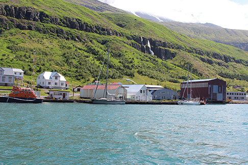
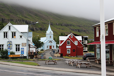
Chores and exploring complete, we set sail at 1600, on what turned out to be a very rough upwind passage to Faskrudsfjordur, arriving at 2200. We had excellent coverage on C-Map of the newly-expanded small boat harbor and could see a 42-foot Norwegian yacht inside but when the depth got down to a half a meter under the keel in the channel, we gingerly backed out. Dallis, standing bow lookout, commented that there was a guy ashore watching us intensely and walking quickly towards the tiny harbor. Bob called out, asking what the depth was mid-channel. The reply was “Half a meter!”, so Bob asked for mooring suggestions. The guy pointed back out the way we’d come, and said, “In front of the yellow house”. Turns out the town had recently completed a handsome new guest pier in front of the old French fisherman’s hospital which is now a classy hotel/museum/restaurant.
Several hotel guests were waiting when we arrived as was Sigmar Hardarson, the guy who’d suggested we moor here. Sigmar crews on the village volunteer rescue boat and he’d been watching our AIS signal on www.MarineTraffic.com before we ever entered the bay. We had a great chat. Sigmar was born in the village, has two kids and drives forklifts in the impressive cooperatively-owned fish processing plant directly off our bow. The operation employs over 200 people and owns three 180-foot fishing boats that work locally and off Greenland catching cod and haddock, much of which is exported to Belgium, Poland and the UK.
 Monday morning Amanda taught sail repair and splicing before our crew went exploring the town and visiting the French hospital museum, which is a tribute to 300 years of French sailors and fishermen working out of this village, losing over 400 boats and 4,000 men. After lunch as we were getting ready to cast off, a waitress from the restaurant asked if she could possibly sail with us to Breiddalsvik, the next bay down the coast. We said yes and Stefania, all smiles, jumped aboard in a flash asking if her boyfriend Bjarni could also come. She also crews on the rescue boat, which her father Oscar skippers, and happily answered all the questions we peppered her with about growing up in an isolated village, including the pronunciation of the Icelandic language.
When I asked if Stefania thought there might be a place for us to moor in Breiddalsvik, she said, “Just a minute”, whipped out her phone and called Ingolfur, the volunteer captain of the rescue boat there, who assured her there would be a berth for us. Stefania steered us into the tiny harbor as her father, who had just driven over the hill to collect her and her boyfriend, looked on proudly from shore. When we asked Ingolfur if we could pay for the moorage he got a quizzical look on his face and told us the woman who might collect moorage fees was out of town, and not to worry.
July 25, 2016, 2015 hrs, 64.09 N, 21.56 W, Log: 196,531 miles Baro: 1012.2, Cabin Temp: 62 F (no furnace!), Cockpit: 44 F, Sea Water: 57.2F (seriously!)
Moored at Brokey Yacht Club, Reykjavik, Iceland
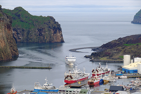
 For the first time in months it got dark enough to require compass and nav lights as we carefully approached Vestmannaeyjar Island in occasional fog and drizzle at 2300. The Imray RCC Faroe-Iceland-Greenland cruising guide mentioned that the harbor had nearly been sealed off by the 1973 volcanic eruption and we were pleased to spot the red buoy marking the edge of the lava flow, squeezing on past it and impressive overhanging 300’ cliffs to arrive in a large harbor jammed with 200-foot fishing vessels and even larger freighters.
We found the small boat harbor but it was filled with whale watch RIBs and local boats. The only empty spot was a small section of the fuel dock and we managed to secure about 1/3 of MT with the rest overhanging. At 0730 I found a harbor employee arriving at the port building and explained where we were moored. She apologized for the lack of space and facilities and said there would be no need to pay because of this. When I mentioned I hadn’t been able to get the self-service fuel pump to work with my credit card, she said she’d call the fuel company. Shortly after a guy showed up with a wireless credit card terminal and we were able to top up our tank.
Upon entering the harbor Donnie had pointed out a new concrete dock, without cleats, loosely lashed to the end of the wharf across from the fuel dock. I asked the harbormaster about this and she called her colleagues and got an OK for us to moor alongside for a few hours. Amanda and Carol figured we could tie to the dock’s rub strake and soon we were all set just in the nick of time for a three-hour volcano summit and town walking tour that Carol had graciously organized.
 Today Vestmannaeyjar is booming with the five fish processing plants and dozens of huge bottom trawlers coming and going at all hours of the day and night. Freighters anchored outside the harbor shuttle loads of frozen and dried/salted fish all over Europe and to Africa. Tourism is also growing with whale and birdwatching tours plus hiking bringing many visitors.
Friday morning, we all took off climbing before breakfast. After returning we covered cruising medicine and once we were underway we practiced towing warp and the Gale Rider drogue before hoisting the storm staysail and trysail. We had fairly light conditions for most of the 130-mile passage to Reykjavik, but managed some good sailing in the early morning hours. We arrived at Reykjavik harbor at 0800 and found a perfect, sheltered spot to moor at the Brokey Yacht Club directly in front of the very new and and impressive Harpa Concert Hall.
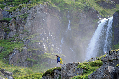 Our adventuresome crew took off in many different directions; Dallis and Sean were picking up rented bikes and a car for mountain biking, climbing and camping activities, Donny headed off to the Golden Circle and Blue Lagoon, Carol was off to experience everything from glacier climbing to diving while Abby and Bob planned to visit a few museums. Amanda and I took an eight-hour Golden Circle mini-bus tour to see volcanoes, geysers, waterfalls and a national park, then set sail to a nearby small town.
 John Neal and Amanda Swan Neal are Editors at Large for BWS and operate Mahina Expeditions, which undertakes sail training for cruisers on adventurous offshore passages.