


When it comes to using tablet computers for navigation, less is frequently more (published January 2013)
We may not have jetpacks, but I can assure you that as far as navigation technology goes, we’re already in the future. It began with GPS effectively eliminating all the manual math required to determine one’s position. It continued with graphical chartplotters and shipboard data systems able to generate tracks and display automatically updated charts, projected course lines, estimated times of arrival, and even autopilot control with wind tracking. It expanded with cell and satellite data integration for weather and enhanced communication options.
Now, you can do all of the above using the same device you use to send and receive emails, video chat with your loved ones, and watch movies to while the time away. You can even hold it all in one hand and slip it easily into a messenger bag or backpack.
Having solo-sailed several thousand nautical miles using nothing but an iPhone or iPad for digital navigation, I can attest to the fact that they are not only exceptionally reliable, but dramatically enhance the capabilities of shipboard navigation systems. Personally, I’ve made the decision to never go back to fixed-location dedicated chartplotters again for my own vessels.
Compared to fixed chartplotters, the advantages of tablets are clear: the devices are more capable, less expensive and can be moved around aboard ship to the places they are maximally useful. But even better, they can be used alongside a chartplotter to add more benefits. Let’s take a look at each of these advantages.
ADVANTAGE: MORE CAPABLE
Tablet computers have many advantages over dedicated chartplotters in terms of capability. Modern networking and wireless technology means they are already ready to integrate into nearly any type of shipboard network. Integrated GPS in most units means they are also an effective standalone navigation tool, much like your handheld GPS but with far better displays, faster response and the ability to do many other tasks (some Wi-Fi-only models may need a tiny GPS that snaps into the dock connector—I use one of these and find it to be exceptional).
And let’s not forget that when you aren’t in need of constant chart display, these devices serve many other purposes onboard, including weather forecast displays, navtex reception and decoding when paired with the appropriate radio, and even integration with two-way satellite text messaging services. That doesn’t even begin to cover the significant social-sharing opportunities, such as using the high-res cameras to share vacation photos with the family back home, checking your social networks for updates, or simply playing a board game off-watch when the angle of heel is too large to allow for physical game pieces to be used. Don’t scoff—it can make a big difference in crew morale on those longer passages!
Plus, with new software and hardware accessories coming out constantly, the features for these devices only continue to grow, and competition in the market means you benefit from innovation. Even today’s chartplotters are learning this lesson and beginning to mimic tablets in both software and touch interfaces far more than their older, stodgier brethren.
ADVANTAGE: LESS EXPENSIVE
The total cost of ownership of a dedicated chartplotter is rather hefty—at least $1,000 or so for a reasonably capable unit with a modest display. In contrast, for around three quarters of that price you can have an iPad with integrated GPS and a truly waterproof case. The dedicated chartplotter requires expensive chart updates and expensive additional hardware if you want to connect it to weather services. The iPad requires little more than a chart app (which, in comparison, is often quite a bit cheaper than a chart card for a plotter model, and can be directly downloaded for instant updates rather than waiting for a card in the mail) to get started and weather apps that use the cell data network are inexpensive or free. So right off the bat, the iPad is cheaper. When you factor in the features, the screen size and the mobility benefits, it’s a slam dunk.
ADVANTAGE: MOBILE
One of the most underappreciated benefits of tablets for navigation is their ease of transport to wherever they are most useful around the vessel. This may be the cockpit or deck, so as to have the chart handy for pilotage, or it may be the main suite, so the skipper can keep an eye on the crew’s course holding skills while off watch.
I often hold mine in place using a self-adhesive strip of two-inch-wide industrial Velcro on the back of my waterproof case. By placing the matching side of the Velcro on various surfaces around the vessel, the iPad is fully secure even in heavy seas, and remains usable to boot, yet easily detached when I wish to move it elsewhere. Combine this with easily positioned mounts such as those from RAM and other companies, and a secure yet adjustable mounting point can easily be established wherever you wish.
In addition, you can use one alongside your existing setup—sharing data off the NMEA bus but otherwise operating as independently reliable systems. Companies such as DigitalYacht make direct Wi-Fi to NMEA gateways, and if your existing chartplotter is new enough it may offer a Wi-Fi option built-in to get you started. Generally speaking, your tablet will operate as a completely independent system from your chartplotter, but will have all the same general capabilities such as autopilot control, instrumentation displays, waypoints and navigation tools.
INTEGRATION WITH CURRENT CHARTING SYSTEMS
Tablet software as it stands today, however capable and fascinating, has one particularly notable challenge—a lack of devices that allow radar and depth-sounder imagery to be viewed using the wireless networks. Fortunately, some of the more clever chartplotter vendors are enhancing their chartplotters with tablet enhancements to bridge this gap. By utilizing the full features of a dedicated chartplotter, including high-definition radar and sonar imagery, but linking wirelessly to a tablet using Wi-Fi or Bluetooth technology, some vendors are offering the best of both worlds.
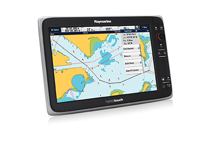
For example, Raymarine’s new “C” and “E” series touchscreen displays and Furuno’s NavNet TZ Touch series offer full remote control and display for many popular tablets, with new features coming on a regular basis. They each offer their own apps to help take maximum advantage of the hardware’s proprietary features. Simrad offers the GoFree wireless remote control app, which provides similarly advanced and innovative functionality for their line of displays and networked instrumentation. The software links to their NSS system with the new WiFi-1 gateway hardware, which also provides the capability for third-party software to directly tap into the data feed—a powerful concept that allows you to use your favorite software with your preferred hardware, regardless of brand.
Other vendors have announced their intention to provide similar functionality, and software changes frequently, so keep a sharp lookout for these features if a display upgrade is in your near future—and if you own one of the later model units, you may be able to take immediate advantage of these capabilities.
 GETTING STARTED
If you’re curious and want to try tablet navigation for yourself, here’s a quick and easy way to do so. It does not require any specific hardware on your boat, and can provide a completely independent navigation system should your chartplotter and onboard data network fail, so it is a handy backup option as well.
First, you need a tablet computer. There are many options out there, but the only system I can personally vouch for being sea-proven in heavy weather and difficult conditions is the Apple iPad. Mine has put up with some serious shipboard abuse and has remained consistently reliable. Fortunately for your budget, there are many options for size, memory, features and price, including the remarkable new iPad Mini which can easily be held in one hand. Even the iPod Touch and iPhone will work quite well, although their smaller screens make reading in harsh conditions difficult. I did sail nearly 1,000 NM using only my iPhone 4, however, so I can vouch for the solution (of course, I use paper charts as well, as any prudent offshore sailor should, regardless of the electronic navigation options at hand).
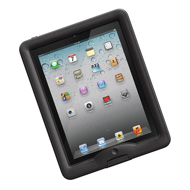
Don’t forget a waterproof case! There are some excellent options available from Lifeproof and Scanstrut, but if you choose a different vendor, make certain that the case is actually waterproof, not just splash resistant. Many popular cases cannot be truly submerged, so be careful when choosing. In a pinch, you can use most any impact-resistant case and a heavy Ziploc bag; the touchscreen still works through the plastic layer. However, this is not a good long-term solution as the bag tends to get a bit foggy from scratches rather quickly and the sealing mechanism will start to leak with rough handling.
If you buy a Wi-Fi-only model, you’ll need an external GPS. I can recommend most any quality Bluetooth GPS or the excellent Bad Elf units, which plug into the dock connector. I’ve used both types with good success.
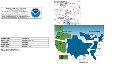
Second, you need some quality software. I recommend iNavX as a solid standalone solution. As with all chartplotting softare and hardware, the charts are a separate issue. If you cruise primarily in the U.S., you can download the free U.S. NOAA charts. If you want to get more serious, I recommend Navionics chart packages (either as complete apps that take the place of iNavX or as a paid download to use within iNavX—both are high quality options, but I chose the latter as I prefer its more advanced navigation features). Compared to the NOAA charts, Navionics have more useful data such as points of interest, enhanced navaid data, and more seamless zooming and panning. There are many other excellent options as well, but this will get you up and running with the least cost and complexity.
Once you have the software installed, you’re good to go. Just run the app, let your GPS get a fix, and you should very quickly be ready to plot a course, watch your track as you sail, and use the onscreen charting much as you would any other chart. Not to mention you’ll start keeping an eye out for other clever ways to use your iPad onboard, such as integrating it with your shipboard data (AIS, depth, wind and other instrumentation), your sound system, and even your radio or satellite phone.
 Tablet navigation is a fascinating step forward in onboard instrumentation and charting. It offers high value and critical redundancy for essential systems while opening new possibilities for understanding, appreciating and safely accessing the beauty in the blue world around us. Give it a try!
Daniel Collins, an ASA certified sailing and navigation instructor, amateur extra class radio operator and small boat racer, enjoys experimenting with marine electronics. He is also actively involved in community-driven social change. Email him at daniel@oddasea.com, or read his blog at www.oddasea.com.