


(published May 2015)
For many years the National Weather Service (NWS) published Marine Weather Services Charts (MSC) that listed crucial information for mariners using their services. There were fifteen charts that spanned all U.S. waters. The page size was 13- by 21-inches, printed both sides, with an annotated great-circle chart of the region on one side and all text on the other. The last printed versions of these are still to be found online from unofficial sources, but they are outdated. The NWS no longer supports them nor makes them available—the only exception is Alaska, MSC-15, which is still available from NWS, although they have trimmed down parts of the original content.
Nevertheless, the concept of the MSC remains crucial to good weather work underway. Environment Canada still offers their counterparts called Mariner’s Guide to Marine Weather Services, which are equally valuable for their waters. One approach to the missing MSC is just to print a copy of the last known version and then make pen and ink updates as needed on that copy. On some charts, the changes are few, or not relevant to your needs, and once updated their value remains high.
In these modern post-MSC days, the latest data are readily available online, but the challenge is finding it and putting it together into a useful format. There is often too much data! We are faced with the same information in multiple formats, with some parts more convenient than others. Or some seemingly obvious thing we would want at hand underway turns out to be difficult to find online. Remember, the goal is not to provide actual resources, but to provide the information we need to use the resources we have access to underway.
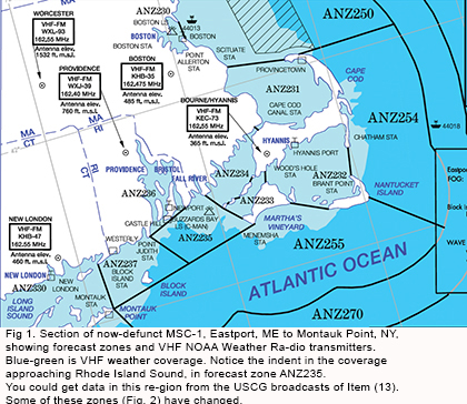
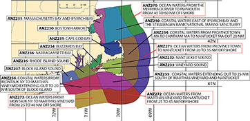
So as a temporary solution—hoping the NWS eventually brings them back—we offer here a way to gather together the same data that was on the MSC charts, which you can then combine into some convenient format of your choosing. A sample section of one of the older charts is shown in Fig 1. Then in the following figures are examples of recent equivalent data found online.
The table below shows the data that were typically on an MSC along with links to where you can get this data to make your own compilation. For regions you plan to sail in, you can download, print and combine into a thin binder what was in the MSC. Having this information at hand is fundamental to taking advantage of the wonderful resources we have available. The exercise will show clearly why we miss the MSC so much.
The latest word from the NWS is they do hope to re-issue some of the MSC as online pdfs, but they do not know when. This might be up to the local NWS offices.
David Burch is the director of Starpath School of Navigation, which offers online courses in marine navigation and weather at www.starpath.com. He has written eight books on navigation and received the Institute of Navigation’s Superior Achievement Award for outstanding performance as a practicing navigator.
1 FORECAST ZONES labeled and outlined on the chart. Coastal zone maps (including Great Lakes) http://www.nws.noaa.gov/om/marine/zone/usamz.htm Offshore zone maps: http://www.nws.noaa.gov/om/marine/zone/wrdoffmz.htm
2 NOAA Weather Radio BROADCAST STATIONS and reception ranges. Start with this index map: http://www.nws.noaa.gov/nwr/Maps/index.php then click to state, then click the station, then click the map for an excellent pdf
3 OBSERVATION STATIONS (lighthouses, buoys, etc) used in NOAA Weather Radio reportsThis is the place we miss the MSC the most, as we have to recreate these plots on our own. The best approach we have found is to start here: http://www.ndbc.noaa.gov/rmd.shtml then click a region,then zoom in for a plot of the stations to print, then click each one to get the name of the station to transfer to your print
4 TERMINOLOGY used in weather reports and forecasts http://www.opc.ncep.noaa.gov/product_description/keyterm.shtml and http://www.weather.gov/glossary and http://www.nhc.noaa.gov/marine/docs/USA_Glossary.pdf
5 LOCAL NWS OFFICES responsible for each of the forecast zones http://www.nws.noaa.gov/organization.php
6 NAVTEX broadcasts. http://www.nws.noaa.gov/om/marine/navtex.htm
7 USCG HF VOICE high seas and coastal broadcasts. http://www.nws.noaa.gov/om/marine/hfvoice.htm • http://www.nws.noaa.gov/om/marine/hfvprod.htm http://www.navcen.uscg.gov/?pageName=mtHighFrequency
8 WWV and WWVH Storm warnings http://www.tf.nist.gov/general/pdf/1383.pdf (page 45) http://www.nws.noaa.gov/om/marine/wwv.htm
9 USCG HF RADIOFAX high seas broadcasts http://www.nws.noaa.gov/om/marine/radiofax.htm • http://weather.noaa.gov/fax/marine.shtml
10 NAUTICAL CHARTS, how to order. www.charts.noaa.gov
11 LIVE BUOY REPORTS by email. You can get not just live buoy reports you can get essentially every NWS product available by email request through their program called FTPmail. See: http://weather.noaa.gov/pub/fax/ftpmail.txt
12 LIVE BUOY REPORTS by telephone. This is the NWS longstanding Dial-a-Buoy program, which remains a very slick system, although smart phones offer even more options. See: http://www.ndbc.noaa.gov/dial.shtml
13 USCG VHF weather broadcasts http://www.nws.noaa.gov/om/marine/vhfvoice.htm These are the repeats and relays of weather information on VHF 22a, which reach out farther than NOAA Weather Radio.
14 CANADIAN weather broad- casts when applicable. Here is the overview of Canadian marine services: http://www.weather.gc.ca/marine/index_e.html And here is Canadian Weatheradio (note spelling): https://www.ec.gc.ca/meteo-weather/default. asp?lang=En&n=792F2D20-1
15 NWS INTERNET LINKS The main list of NOAA/NWS Internet sites is at: http://www.nws.noaa.gov/om/marine/mlinks.htm A shortcut url to all marine weather resources(which we hope will not change) is: www.weather.gov/marine
16 WEATHER SAFETY TIPS for mariners, unique to the region. The closest we could find in the same spirit: http://www.ec.gc.ca/meteo-weather/default.asp?lang=En&n=656C03FF-1 For more see: www.starpath.com
17 PORTS — Physical Oceano- graphic Real-Time System. An amazing resource for quite a few places around the country: http://tidesandcurrents.noaa.gov/ports.html
18 NOAA Weather Radio by telephone Covered well in AK on MSC-15, but this seems to be a service of the local NWS Offices, so you will need to check with your local NWS Office. See Item (5).
19 General and special information about the local forecast zones covered. Start by finding the main link to the local NWS Office from here: http://www.nws.noaa.gov/om/marine/marine_map.htm Then there is much information about specific regions. The unique channel wind map on the back of MSC-13 for HI is one good example.
20 Definitions of VHF WX channels by frequency Most resources define the VHF broadcast products by frequency, but on the boat we may only have channel names, wx1, wx2, wx3… so this can be useful data: http://www.nws.noaa.gov/os/marine/wxradio.htm
21 Unified Analysis Maps not cited on historic MSC,but new valuable resources http://www.opc.ncep.noaa.gov http://www.nhc.noaa.gov/tafb_latest/USA_latest.pdf