


Cruising the atolls of Tuamotu brings spectacular marine life and scenery, as well as fickle and potentially unfriendly passes (published February 2015)
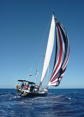
Steve and I stood over the chart table considering a parade of small blue circles that marched across the expanse of blank white that defined the Pacific Ocean. On paper our next destination looked like soggy remains of the Cheerios that I left floating in my morning cereal bowl. In reality they would appear like a mirage as a sliver of sand, a few palm trees and a froth of surf crashing in an endless blue sea.
The Tuamotu Archipelago is made up of 78 islands scattered across some 1,100 nautical miles of the South Pacific. Situated 200 miles northeast of Tahiti each “island” of the group is actually a coral atoll, the remnants of a group of ancient volcanos. Each atoll is a collection of small islets, or “motu”, that string together to encircle a lagoon.
INFAMOUS PASSES
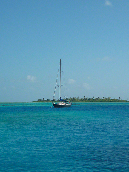
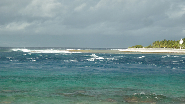
To enter the atoll you must traverse a pass between the motu, an activity that is dependent on tide, wind and often a little bit of luck. The passes can be fickle, unpredictable and potentially dangerous, but get through one and the boat is instantly transported into another world.
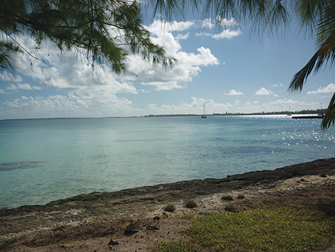
Protected from the open ocean swell, the calm lagoon inside provides a respite for weary mariners. On a sunny day the view from the cockpit is what every postcard from the South Pacific longs to be; dazzling shades of blue littered with vibrant fish and colorful coral, and white sandy beaches dotted with swaying coconut trees. It is worth every nerve-wracking, hair-raising moment that sailing through that small gap in the reef entails.
The first atoll we visited was Kauehi (15°52″S, 145°8″W). We arrived at 1600 under fairly clear skies and surveyed the cut in the reef through binoculars, agreeing that it looked a little churned up, but definitely not surf-able. We decided to turn Kate towards the pass, roll away the headsail and turn on our engine.
The pass was narrow, 20 meters wide at best. With each excruciating moment it took us to motor slowly into the pass, the conditions continued to change for the worse. There wouldn’t be much room for error, and probably no room for turning around.
The wind was gusting 30 knots and funneled between the adjacent motu and down the channel. The current racing out of the lagoon was increasing as the falling tide pushed between the edges of the reef. At the narrowest point in the pass it felt like we were at a standstill, the engine was at full throttle but the shoreline on either side of us didn’t seem to be moving. I was starting to get nervous, had we made a mistake? I looked at Steve; his calm reserve was the only thing that was keeping me from panicking.
“Should I roll out a little headsail?” I suggested, trying to sound nonchalant.
“Sure, couldn’t hurt.” Steve replied, his voice not giving away his growing concern.
I pulled out half the sail and it made no difference. I quickly let out the rest and sheeted in hard. With all of our 135 percent genoa unfurled we picked up just enough speed to push through the bottleneck in the channel. When we were released from the clutches of the rushing water, the ocean once again felt fluid instead of thick like oatmeal and we started to pick up speed.
STUNNING ATOLLS
Typical of most of the atolls, the charts for the inside of the lagoon were incomplete; there was nothing but white space outside the shipping channel. We carefully picked our way across the lagoon in the dimming light to anchor off the village on the other side. By the time we finally arrived it was dark and the lights on shore confused what we hoped were working navigation beacons. Hesitant to get too close to shore, we dropped the anchor just outside the shipping lane when the depth meter showed 16 meters. We hoped an inter-island freighter wasn’t due to arrive through the night.
The next morning we could see the masts of other yachts behind a point of land that was the anchorage. I had felt the anchor bite hard the night before and now as I retrieved it, it jumped and snagged on the unseen maze of coral that we had dropped it in. The anchor came to a shuddering halt and held fast. Nothing we did on deck would free it, so Steve suited up and dove in. He spent half an hour on the bottom wrestling and untangling the chain from around a bommie.
In good light we had no problem picking our way around the coral heads. We found a patch of sand behind the other boats and enjoyed the shelter that the thick wall of palm trees afforded from the howling trade winds. In the sunshine the lagoon was endless shades of greens and blues, with the stilted huts of pearl farms dotting the horizon. Last night’s worries and the struggles of the morning seemed to melt away.
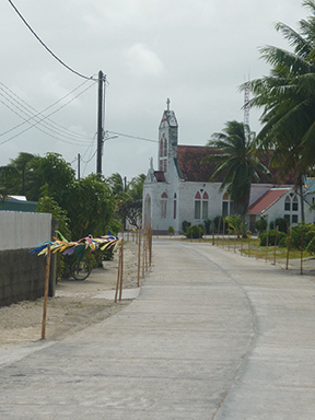
We stayed when all the other boats left and for three glorious days had the place to ourselves. We spent hours walking along the shoreline on the seaward side, exploring the flotsam and jetsam that had washed up after traveling across thousands of miles of ocean. We explored “town”, a one lane, coral rubble path that ran the short length of the motu. We were surrounded by casuarina pines, arthritic looking frangipani, the occasional pawpaw plant and, of course, coconut palms. Home to the few island residents, the village store and the church, it was quiet and tidy with welcoming locals. It felt like we’d found our own little slice of paradise.
FAKARAVA
Now that we had one reef pass under our belt, we knew what not to do. We studied tide charts, waited for the wind to ease and plotted our course to our next destination, Fakarava (16°03″S, 145°39″W).
Fakarava is the second largest of the Tuamotu atolls and is easily identifiable on a chart by its distinct rectangular shape. We would need to catch the outgoing tide in the morning at Kauehi and sail to the pass at Fakarava in time to catch the afternoon ingoing tide. The north pass at Fakarava, Passe Garuea, is the largest pass in the Tuamotu and is renowned for its strong currents. We’d already learned the nightmares of a mistimed arrival and it wasn’t something we were keen to repeat.
The passage out of Kauehi was uneventful and after sailing out of the protection of the reef, the ocean floor fell away sharply and we once again could feel the deep ocean swell under the keel. The wind was perfectly aft of the beam and we were making good time until that afternoon when the wind eased. I had an inkling of déjà vu.
When we finally reached the mile-long opening at Fakarava the water was almost glassy. We had arrived perfectly at slack tide despite our tide tables indicating we were an hour late. It all seemed like a bit of a guessing game, and happily this time we’d won.
Declared a UNSECO Biosphere Reserve, the big draw here is under water activities. The southern pass, Tumakohua, is known as an excellent place to drift dive or snorkel amongst the sharks and other plentiful tropical fish, and is suitable for experienced divers and novices alike. Over the next few days the anchorage was a constant shuffle of boats arriving and departing, including a couple of super yachts that had no problem traversing such a wide, deep pass.
ANSE AMYOT
When we left Fakarava we turned west. We were heading to Anse Amyot (15°49″ S, 146°0″ W), where several of the boats we’d been hopping around French Polynesia with were gathered. This indent on the sea-facing side of Toau atoll had all the characteristics of a lagoon: good anchorage, protection from prevailing winds and was teaming with marine life. But since it was technically on the outside of the lagoon it didn’t require traversing another unpredictable pass, and by then we all needed a break.
A well-marked channel in the reef opened into a crystal clear bay that held a half dozen boats. A local family here had laid out a mooring field so we picked up a buoy and settled in for a couple relaxing days knowing that our departure would not be dictated by tides and conditions in the pass.
During our stay in Anse Amyot I spent more time in the water than on it; snorkeling around the boat, at the entrance to the harbor and along the outer reef edge where the bottom falls away into impenetrable inky blue. Sharks, delicate reef fish, a variety of cod and trout, parrots fish, brilliantly colored frilly lipped clams, lobsters, rays and a local group of huge Maori Wrasse kept me coming back for more.
The day we departed, Kate swung quietly on her mooring in the turquoise bay, the gentle ocean swell a soft clap on the outside reef. Each new atoll we visited had upped the ante, dazzling us with its austere beauty and incredible marine life, each time making it harder to leave. But, we had one last atoll to visit before heading south to Tahiti, the crowds and pending boat projects.
RANGIROA
Rangiroa (15.12°S 147.64°W) is on the northwest edge of the island chain and is not only the biggest atoll in French Polynesia but also one of the largest on the planet. It is over 42 miles long and up to 17 miles wide, but only 35 meters at its deepest. It is a great shallow bathtub that empties through two passes on its northern side.
Our passage from Toau was an overnighter and as dawn broke we approached the Tiputa Pass. We stood off, waiting for the tide and watching the conditions as the sun struggled to break through the low clouds. After watching another yacht take down their sails and get tossed about as they motored through the pass, we knew we’d made the right decision. Half an hour later the large rolling waves subsided and we sailed in on the current, successfully navigated around a small islet in the center of the channel and found our way to the anchorage just north of the pass.
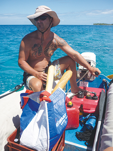
The next morning we dinghied along the shore to the village of Avarotu, four miles north, as there was rumoured to be a store there. There is a fine line to walk when supplies arrive by ship and bad weather can cancel a delivery. Although we like to support the local economy we are conscious never to empty the shelves. We came fully provisioned for our month long stay in the islands and we have a watermaker on board, which, in a place where locals depend solely on water collection, ensures that we are not a burden on the places we visit. That morning we were delighted to find a large, well-stocked island supermarket where we could exchange our empty beer bottles and pick up a fresh baked baguette. A simple street side café enticed us, so we sat in the shade and enjoyed a serving of poisson cru (raw fish “cooked” in lime juice and coconut milk), a cold drink and the broad, smiling faces of the locals.
We visited Tiputa Pass several times to snorkel and at the turn of the incoming tide we motored the dinghy into the current with all of our gear on then cut the engine and quickly ducked over the side. Holding onto the dinghy we were whisked into the lagoon, passing sharks, barracudas, large trevally, schools of long nosed unicorn fish and several other species that rushed by too fast to identify. At mid tide we sat in the small park adjacent to the pass and watched as dolphins leaped and surfed on the roiling breakers. One afternoon there was a large manta ray that circled around Kate, shy and aloof unlike the half a dozen white remoras that clung to her belly and darted out for food scraps tossed overboard.
Since this is a very large atoll, there are charted channels across the interior, making exploring a considerably less stressful activity. With steady trade winds blowing, but protection from the long ocean swells by the encircling motu, sailing inside the lagoon is more akin to being on a small lake than the open ocean passages we had become so accustomed to. One morning, after the sun was high enough to make the few random bommies visible, we threw up the kite in 20 knots of breeze and skidded across calm waters. After months of long passages and the worries of navigating in the Tuamotu, it was a joy to sail just for the fun of it.
We had spent a month cavorting around the atolls and could have easily stayed for several more weeks but our clock was ticking and our weather window for sailing to Tahiti was open. On a bright sunshiny morning we hauled up anchor, raised the sails and pointed the bow towards the pass.
Conditions started out well but quickly deteriorated as we moved farther into the long channel. We tried to sail the outskirts of the current but were drawn sideways into the main tidal bore. We were getting pulled towards the reef edge in the cross current where the pass gave way to the open sea. My knuckles were white from holding onto the dodger and my body braced against the heave and sway of the boat. After several minutes of clawing our way through the waves we were finally free of the menacing pass. Wet, mentally taxed and physically exhausted, we felt like we had just been unceremoniously chewed up and spat out of Tiputa Pass. It felt like our final sloppy kiss goodbye from the Tuamotu.
Heather Francis was born in Nova Scotia, Canada. She and her Aussie partner, Steven Hertik, bought their Newport 41 Kate in 2008 and have been sailing ever since. For more of their adventures log onto www.yachtkate.com.
The more resources you have at hand for navigating a place like the Tuamotu the better. We found that the charts were accurate and aids to navigation well maintained by the French Navy, but a prudent mariner will always rely on experience and common sense. One guidebook that we found particularly helpful was Guide to Navigation and Tourism in French Polynesia, by Patrick Bonnette & Emmanuel Deschamps. While a bit on the pricey side, it is a very thorough book that covers not only the larger, more commonly visited atolls but a selection of the smaller and more technical ones as well.
There are no official Ports of Clearance in the Tuamotu, however, you can make first landfall at a larger atoll such as Rangiroa and check in with the Gendarme, local police, who will forward details to Customs and Immigration in Papeete. Bear in mind that the Gendarme are not part of the regular check-in process and may not be familiar with the procedures. Customs vessels do patrol all of French Polynesia’s waters and rely on the information about boats provided to Papeete.
As a UNSECO Biosphere Reserve, Fakarava, and the atolls under its jurisdiction (Aratika, Kauehi, Niau, Raraka, Taiaro and Toau), have strict regulations for anchoring, fishing and rubbish removal. Check at the local Town Hall for a copy of the current rules and regulations.