


As technology continues to drive deeper into our lives, it’s important to remember that an elegant simplicity still exists with the traditional navigational tools and solutions (published January 2016)
I’m scrambling. With one and a half days before I fly to France for another transatlantic passage, I’m deeply immersed in the process of procuring a new battery for an old Iridium phone, collecting the correct Navionics chips for our eventual landfall in North America and initializing and authorizing my new InReach tracking and messaging device. The labor saving devices are beginning to overwhelm the tasks I’m going to need to accomplish.
Nav stations have changed, and they are continuing to change. We now have more means to gather positioning, performance and weather data than ever before. In addition to GPS, VHF, SSB and weatherfax, we now have satellite communications to connect us to the internet, computer displayed digital charts, navigational plotters with weather displays, cell phones and various other gadgets to help gather an ever-increasing amount of information. But despite all of the new tools, the older, more traditional tools not only have their place in the modern nav station, they still provide the most reliable foundation for our work as navigators and onboard decision-makers. We still need the means and understanding of how to put an LOP (Line Of Position) on a paper chart.
Experienced navigators still have their preferences. What we grow up with plays a big role in what we prefer to continue to do. Aboard one Swan 56 with which I raced, one of the navigators was a “triangle guy”. Using a couple of right triangles, he liked to put them together, and transpose a bearing line off the compass rose by sliding one triangle against the other across the chart. It’s a technique that has worked well for centuries, and as a graduate of one of the country’s maritime academies, he has certainly had qualified instructors guide him in that technique’s effective use. Warren Luhrs, prior to his 1986 singlehanded round the world race campaign was also a “triangle guy”. No parallel rules for these guys! They’re fast and effective with a manual system that they prefer. They worked then, and they still work now—but only if you actually have them onboard.
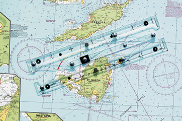
Other sailors prefer the more common parallel rules that consist of two —usually plastic—rulers joined by a set of hinges. Variations exist within this category, but the principle is much the same. Recently I even purchased a set of parallels with three rulers, enabling a bit more flexibility and speed while crossing from the compass rose to the LOP I was trying to draw. Chart tables can be small as computers continue to take up an increasing amount of limited space, and I wanted to try to reduce the number of times I’d have to move the ruler while bouncing around in the nav station. The set of triple rulers helped, and it was a system with which I was already familiar.
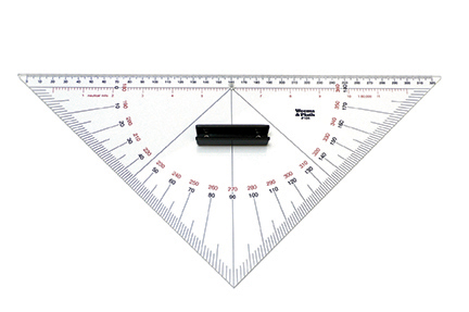
Even manual things have changed and improved over the years. Several years ago I spotted a Portland Plotter in a chart house. I didn’t take much notice. It seemed like just another plastic gadget I really didn’t need. During one race across the South Atlantic, another navigator and I were working together in the nav station. He said, “You’ve got to check this out. It makes plotting a lot faster and easier.” Also a graduate of a maritime academy as well as the winning navigator in one of the earlier round the world races, it made sense to listen to him. I have checked it out, and now, for me, it has replaced the parallels I used to prefer.
The main advantage I find in the Portland Plotter is that it’s no longer necessary to move anything across a chart. If, for example you’d like to draw your heading from a known position, line up the variation on the dial with your desired course. Point the ruler generally in the direction of the bearing or course. And rotate the ruler slightly until the grid pattern in the middle of the dial lines up with one of the latitude or longitude lines on the chart. Essentially your compass rose, complete with local variation, is on the tool rather than making it necessary to transfer that information across a chart. I can’t count the number of times I’ve had to re-trace my tracks with parallels while plotting positions from LOPs taken from bearings on known objects as the boat jumped off waves and I bounced around down below in the nav station. With the Portland Plotter, you just set your course to the local variation, lay the ruler on your position and superimpose the lines. It’s a reliable and accurate manual system.
These more-or-less traditional tools have an advantage over some of the modern electronic tools in the fact that they ARE manual. The day or night that the batteries go flat, the system bus is shorted out for the instruments, the computer crashes, lightning hits the boat, a wave comes through the hatch or any of a multitude of other “unforeseen” problems occur, you’ll be very happy to have and know how to use the manual, traditional tools. You still need to be able to navigate your vessel safely.
You may be able to get a bearing to a lighthouse off the GPS-driven computer display or plotter that uses your tracking software. But if there are problems, you will certainly be glad that you had a good hand-bearing compass and had experience in using it. Even without equipment failures, the night you’re approaching another vessel, you will want to know whether they are gaining or losing bearing as you close range. If their bearing is remaining the same and they are within a half-mile, you will certainly want to modify your course or discuss the matter with the other captain on the VHF. When you determine early that they are gaining or losing bearing, you will know whether they are going to pass clear ahead or astern. And none of that will be on the computer screen in the nav station unless you have AIS and it’s working properly on your boat as well as the other vessel. That situation may be illuminated on radar, but radar, too, can be subject to electrical problems.
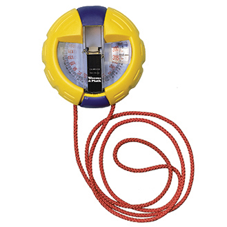
Hand-bearing compasses come in a variety of sizes and types. A quick google search can find a number of digital hand-bearing compasses, including old Autohelm electronic models, capable of retaining several bearings in memory and lighting the digital display at night. Batteries have been long-lasting, and the unit is small enough to conveniently fit in a pocket or be worn around the neck under the clothes so it doesn’t catch on things. As it turns out, even my new InReach satellite communications device has a very basic compass. Non-electronic models come with handles, lights and various sights. My favorite is a simple “hockey puck” type. It can be illuminated by charging with a flashlight or other light source. The numbers are large enough that I can read them—even without my reading glasses. Mine is a French Mini 2000, made by Vion. Besides wine, food, and love, it may be one of the best things the French make. It’s elegant in its simplicity.
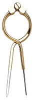
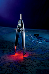
Elegant simplicity for the navigator doesn’t just stop with taking bearings, though. Simple dividers also come in a variety of shapes and designs. Some are merely two straight-legged hinged arms. Some have a round top, so that you can conveniently squeeze the top to open the arms. After a little use, the motion becomes quite fluid with one hand while you can still try to hold on to something down below in a boat slamming off waves. Other dividers have a screw-post adjustment that allows for controlled opening and closing of the arms. If occasion takes you aboard boats that bounce a lot, having the screw post means that when you put the dividers to the chart, you won’t be opening and closing the arms every time you slam off another wave. Racing on multihulls, and going long distances on a variety of boats in a wild mix of conditions, I’ve grown to appreciate the dividers with a screw-post adjustment.
The tools to put good marks are just part of the equation. You also need good charts. They should be updated regularly, and you should be aware of the chart datum to which they refer. Make sure that the information you’re getting off your GPS is consistent with the datum of the chart. If you don’t, it’s quite possible that while you’re sailing safely within a marked channel during the day, the GPS position, plotted to the paper chart, might indicate that you’re somewhere up on the beach. That little discrepancy has happened to me in Polynesia and elsewhere. Some charts such as Imray, come in a waterproof paper. Others, such as Admiralty, have a heavier quality paper than the U.S. charts and occasionally have profiles of the land and its various approaches. And ChartKit offers a collection of charts within a package. The price can be somewhat less for a pretty complete set of charts for a particular area, but sometimes the charts within the kit aren’t always oriented north up. Be aware of what you’re looking at before you need the information in a hurry.
This is where I depart from more of the traditionalists. I like to fold my charts, not roll them. I want them to lay flat on the nav table rather than curl up and run across the nav station. When I fold them, I want the written title to the chart, its number, and some identifier I create that determines when during the passage I will be using the chart. The writing should be in the same corner for each of the charts so that when I’m searching for the next set of charts, an approach for example, I won’t have to open each chart to find what I’m looking for.
Prior to departure, I like to plot the rhumbline between waypoints and label their range and bearing to the next waypoint. And, sometimes I will even highlight those range and bearings with a highlighter pen. I know that flies in the face of convention, and highlighter pens are not erasable. If things are penned onto charts, the charts can quickly become cluttered and unusable. But for a race, I may need information quickly, and it may be in the middle of the night. The cost of chart replacement may be a secondary consideration in such situations.
While even the more traditional tools have had some changes over the last few years, the principles remain the same. The fact that they’re manual means that they’ll work while in some cases the newer, glitzier tools may fail. As the navigator, the failure of your tools won’t make a good excuse for the failure in your job. It is important for all of us to do the best that we can. Our vessels and those aboard her depend on it.
Bill Biewenga is a navigator, delivery skipper and weather router. His websites are www.weather4sailors.com and www.WxAdvantage.com. He can be contacted at billbiewenga@cox.net. photos courtesy Weems and Plath.