


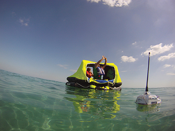
Its’ not what any of us want to do, but it may be the best alternative when confronted by disaster |
I am not a big fan of dealing with problems. In fact, I dislike problems to the extent that I try my best to avoid them. Plan ahead. Understand your equipment and its proper use. Prepare and make sure all safety systems are in place, fully functional and readily available. When we’re ultimately confronted by the sometimes-inevitable problems, I want them solved as expeditiously and thoroughly as possible. I don’t want to revisit them again the following day, so the safety gear I select must work. All the time.
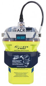 Those maxims are etched in my mind when it comes to equipment that might mean the difference between life and death, such as that seldom used device, the EPIRB (Emergency Position Indicating Radio Beacon). Today’s recreational tracking devices such as a SPOT, though very beneficial in many cases, are still no substitute for an EPIRB in an offshore emergency.
EPIRBs can transmit on up to two separate frequencies: 121.5 MHz, sometimes available as a homing beacon and 406 MHz. Starting in February of 2009, 121.5 MHz and 243 MHz COSPAS/SARSAT stopped processing signals transmitted on those frequencies. COSPAS/SARSAT began as a multilateral cooperative project sponsored by the U.S., Canada, France and the former Soviet Union in 1979 to reduce the time to rescue air and maritime victims or others, using satellites to increase the probability of saving lives. Based in Montreal, as of 2011, 26 countries (Algeria, Argentina, Australia, Brazil, Chile, People’s Republic of China, Greece, India, Indonesia, Italy, Japan, Republic of Korea, New Zealand, Nigeria, Norway, Pakistan, Peru, Saudi Arabia, Singapore, South Africa, Spain, Thailand, Turkey, United Arab Emirates, United Kingdom and Vietnam) and two organizations (Chunghwa Telecom of Chinese Taipei and the Hong Kong Marine Department) are providers of ground segments, while 11 countries are user states (Cyprus, Denmark, Finland, Germany, Madagascar, Netherlands, Poland, Serbia, Sweden, Switzerland, Tunisia). The term “SARSAT” is an acronym for Search And Rescue Satellite Aided Tracking; COSPAS is a Russian abbreviation for Space System for Search of Vessels in Distress.
In emergencies, rapid detection is of paramount importance. Air crash victims surviving the crash have less than 10 percent chance of survival if the rescue is delayed beyond two days. If the rescue can be accomplished in less than eight hours, their chance of survival is increased to better than 50 percent. Timely handling of maritime emergencies is no less important given the increased risk of hypothermia and exposure. To decrease the recovery time and increase the reliability, the system is comprised of three main subsystems: the emergency beacons, the COSPAS or SARSAT satellites with their repeaters and processors, and the ground stations. The system can be used in two coverage modes: regional and global.
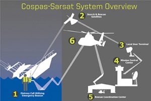 COSPAS/SARSAT uses multiple, low altitude (850-1,000 km), LEOSAR polar orbiting satellites to “listen” for the distress signals and GEOSAR geostationary satellites including GOES 12, 14 and 15. The signals received by the satellites are relayed to a series of Local User Terminals (LUTs) ground stations where the location of the distress call is determined by measuring the Doppler shift caused by the motion of the satellite and the position of the beacon emitting the distress signal. In the case of a single GOES observed transmission, the occurrence of an emergency can be indicated, but the location can’t be determined because the satellite is “stationary” relative to the beacon. An emergency indicated by a GOES satellite must wait for a polar orbiting satellite over flight to confirm location of the beacon emitting the distress signal.
Currently, COSPAS/SARSAT is using five NOAA polar orbital satellites, NOAA 15, 16, 17, 18 and 19, as well as METOP-A. The two Soviet orbital satellites are now offline. When the satellite receives the distress signal, the identification, location and time data is relayed to a Mission Control Center (MCC) that alerts the appropriate Rescue Coordination Center (RCC) or the MCC in another country. The RCC then begins the actual search and rescue operation in accordance with local procedure. I would like to note that the “Admiralty List of Radio Signals, Vol. 5, GMDSS” has virtually every rescue service in the world listed, along with their contact details. It’s a publication that is available through most charthouses. If you are ever forced into a liferaft, you may want to have your EPIRB, satellite phone and the phone number for the closest RCC. You will be able to tell them in detail about your current condition as well as be able to directly assist with your own rescue.
Originally the 121.5 MHz beacon system was designed to be monitored by overflying aircraft. But the aircraft had to be within direct line of sight of the beacon, and, although aircraft regulations required that aircraft making long flights over water must monitor the distress frequencies, flights over land had no such regulation. The 121.5 MHz system, when monitored by aircraft, also did not provide for the exact location of the distress beacon, so a large diameter search area would be necessary unless the search craft was equipped with a homing device. The aircraft would be within about 185 mile radius of the distress.
![]() The satellite system allows for location fixing using the Doppler shift. A distinct advantage of the 406 MHz EPIRBs is that they should be registered with the MCC database for identification purposes. (In order to register your beacon, you can go to: https://beaconregistration.noaa.gov/rgdb/). The type of vessel, size, home port, contact numbers, etc. are kept on file using a 15 hexadecimal alphanumeric identifier that is usually indicated on the outside of the EPIRB beacon. The 406 MHz EPIRBs are going to be with us for a while.
The satellite system allows for location fixing using the Doppler shift. A distinct advantage of the 406 MHz EPIRBs is that they should be registered with the MCC database for identification purposes. (In order to register your beacon, you can go to: https://beaconregistration.noaa.gov/rgdb/). The type of vessel, size, home port, contact numbers, etc. are kept on file using a 15 hexadecimal alphanumeric identifier that is usually indicated on the outside of the EPIRB beacon. The 406 MHz EPIRBs are going to be with us for a while.
In the spacecraft, a repeater data system relays the 406 MHz signals in real-time to the ground station to be picked up if a ground station is within range. In addition, when 406 MHz signals are received, an onboard signal processor receives the signals and preprocesses and records the data for transmission to the ground at a later time in the playback mode when the satellite is within range of a ground station. LEO satellites transmit to a LEOLUT ground station, and GEOS satellites transmit the data to a GEOLUT earth station. This enables all areas to be covered; even those areas outside of the range of a ground station, which gives the system complete global coverage. But the storing and relaying is only available with 406 MHz units, so they are the only EPIRBs with complete global coverage.
The information received at the LUT is forwarded to the MCC (Mission Control Center) and on to the RCC (Rescue Coordination Center) to determine who will be involved in the operation and respond to the distress. In the U.S., the Air Force, Civil Air Patrol, Coast Guard, Coast Guard Auxiliary and state and local police play major roles in the rescues. If the rescue is to take place far offshore and the RCC deems the assistance of merchant vessels is necessary for assistance, AMVER, one of the Coast Guard’s worldwide “tools,” may be brought in to help as well.
AMVER (Automated Mutual-assistance VEssel Rescue system) had been operated by the U.S. Coast Guard on Governors Island New York, but is now located in Martinsburg, West Virginia. It rapidly grew from a system primarily concerned with the North Atlantic to the worldwide safety net that it provides today. Participating merchant vessels, about 15 percent of the world’s ships, report their vessel identification, position, size, onboard medical capabilities and so forth daily using satellite communication or SSB radio through coastal stations around the world. The world’s first coastal station, Gothenburg Radio in Sweden was also the first to participate with AMVER. Although there are now fewer coastal radio stations, many of the coastal stations provide the link between the ships and AMVER free of charge as a service to mariners around the world. AMVER also cooperates with other vessel reporting systems such as Australia’s AUSREP (Australian Ship Reporting System).
With the advent of the Global Maritime Distress Safety System (GMDSS), the role of AMVER was redefined to complement the emerging technology. Rescue coordination centers around the world began using EPIRBs, Inmarsat-C and Digital Selective Calling terminal auto-alarms to “take the ‘search’ out of search and rescue.” As satellite communications capabilities are becoming more ubiquitous, means of getting emergency information back to rescue services is also changing. When the RCC determines that a rescue will need the assistance of another vessel, the RCC contacts AMVER, and AMVER, in turn, calls upon the closest participating ships for aid. Assistance is granted to anyone at sea requiring it, regardless of the flag of the vessel.
Real life stories abound about how EPIRBs have saved people’s lives. The stories are real, and have included friends and shipmates of my own. Years ago, it even included Rich Wilson, record setting long distance sailor and two-time Vendee Globe competitor. After the initial signal had been received from Wilson’s EPRIB aboard Great American by GOES-7, the RCC notified Boston Coast Guard that there was a vessel reporting an emergency. Shortly thereafter, a NOAA satellite carrying both EPIRB and ARGOS tracking equipment confirmed Great American’s position 350 miles northwest of Cape Horn. The RCC called AMVER to help orchestrate a rescue. ARGOS contacted the shoreside router for Great American, and AMVER to supply any further details that may help in the operation: color of the bottom, size and type of liferaft, etc. After consulting their tracking system for available ships in the area, AMVER requested the assistance of the 900 foot refrigerated container ship, New Zealand Pacific, which was within 75 miles of the stricken multihull.
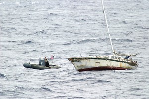 Rich Wilson and Steve Pettengill were rescued from their floundering vessel within 15 hours of their initial request for help in a remote part of the ocean. Although a great deal of the credit must go to the skill of the crew of the New Zealand Pacific and Wilson’s and Pettengill’s good fortune in having that ship in the vicinity, the rescue demonstrates that the COSPAS/SATSAT system along with the RCCs and the Coast Guard’s AMVER system are capable of accomplishing amazing tasks.
It still remains the task of the sailors at sea, however, to understand how the system works and how we can help keep it efficient. The best way to keep the system efficient is to be prepared with suitable equipment and skill to avoid problems in the first place. Being prepared for the “unforeseen” is the next best way to be handle problems. Having the right safety equipment—including but not limited to a tested and registered EPIRB—onboard will be a big step in the right direction when serious problems can’t be avoided and you’re forced to flip the switch on your EPIRB.
Bill Biewenga is a navigator, delivery skipper and weather router. His websites are www.weather4sailors.com and www.WxAdvantage.com. He can be contacted at billbiewenga@cox.net