


Tracking devices abound, and they are only improving (published June 2012)
The skipper on Thursday’s Child took a few moments out from dealing with the heavy weather on deck. It was cold. And the Southern Ocean waves were huge—40 feet or higher. More than 2,000 miles from land and singlehanding the 60-foot monohull from Cape Town, South Africa to Sydney, Australia, he could use the time below to send his position. The cutting edge technology—a laptop interfaced with an Argos transponder—would enable him to send 34 characters, including his latitude, longitude, wind speed, wind direction, boat speed, heading, barometric pressure and a few words about his condition.
In 1986, the laptop alone was a marvel of engineering. To have the computer interfaced with a satellite transponder and able to communicate messages in near real time back to shore was almost beyond imagination. Meanwhile, back in Newport, RI, I could plug my Apple Macintosh plain vanilla box into a phone outlet and, via a Time Net connection, access data from computers in Toulouse, France or Washington, DC every hour and a half as the information—a block of numbers—was downloaded from the satellite passing overhead.
 That was then. The state of global communications and positioning has changed greatly since those distant days. Asset tracking by satellite is growing, whether it’s called M2M (machine to machine) or something else. There are four different satellite systems that we’ll discuss: Iridium, Globalstar, Inmarsat and Orbcomm.
IRIDIUM
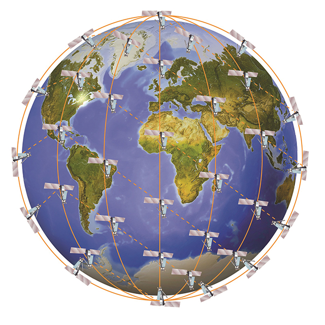
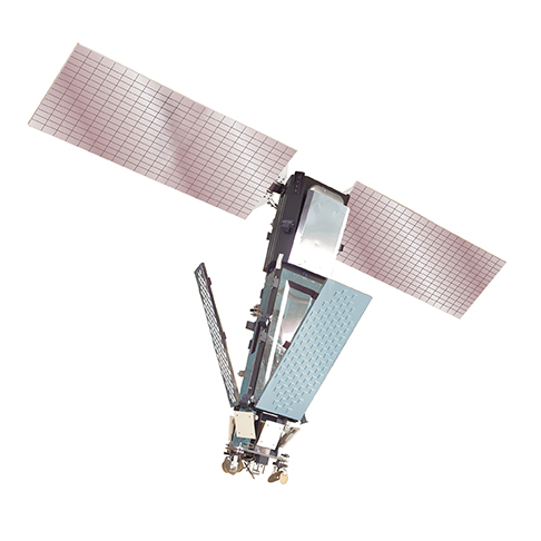
Iridium (www.iridium.com) uses a constellation of 66 satellites to uplink a message, relay it from satellite to satellite, and then download it to a land earth station in Arizona to get on landlines or other terrestrial means of communications. The message moves at the speed of light, so there’s no real time delay to speak of.
The other companies use a variety of geostationary or polar orbiting satellites to get and relay the message. Some have slightly more coverage (including or not including the polar regions or coastal versus completely covering all ocean regions). Iridium, as most people know it, provides portable phones that allow for two-way communications for voice and data. They also have third party vendors who provide tracking devices to enable passive remote area asset tracking.
GLOBALSTAR
Globalstar (www.globalstar.com) had issues with several satellites that went offline a few years ago, and they’re still trying to get new replacements. Several years ago, radiation destroyed some of the hardware on the satellites used for duplex communications—the kind we use when talking with each other on the phone. Hence, there can be a 20-minute or longer delay in some of their voice transmissions as the fully operational polar orbiting satellites come into and go out of range.
The equipment used for simplex communication wasn’t adversely affected, however. Simplex is a “one-way” type of communication. Since Globalstar is the satellite provider for SPOT devices (tinyurl.com/7fx6vr4), which send positioning and limited pre-formatted messages by simplex transmissions, those devices on Globalstar work quite nicely, covering most of the globe, though not all. Keep in mind that SPOT and other simplex devices only transmit in one direction.
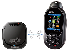 SPOT is one type of relatively low cost tracking device, targeted at the backcountry and marine markets as well as mainstream consumers. Global Ocean Securities Technologies’ (GOST) EZ Tracker offers another approach (www.gostglobal.com). The EZ Tracker is battery-operated, lasts up to 180 days, and can transmit sensor-relayed information, providing additional data about your vessel such as security, surveillance and engine monitoring. Communications via the GOST EZ Tracker are by terrestrial Wi-Fi networks, cellular networks and satellite. The G3G GSM Communicator features Quad band GSM/GPRS/EDGE 850/900/1800/1900 and Tri-band UMTS/ HSDPA frequencies 850/1900/2100. For situations that go beyond land-based systems, GOST uses the Nav-Tracker 2.0 to keep you informed of your boat’s location through a GPS service provided by the new Inmarsat iSat M2M service.
INMARSAT
Inmarsat has a wide variety of third party tracking options available through their SkyWave program, which uses the IsatData Pro. For Inmarsat product comparisons, visit www.skywave.com. You should be aware that when Inmarsat says that they offer global communications, they do not include polar regions. Their satellites reach from 70 degrees North to 70 degrees South latitude—ample enough for most users. But if you’re planning to head to the Norwegian Arctic, you should think about Iridium, a truly global system.
ENDLESS POSSIBILITIES
A quick study of the Iridium product list (tinyurl.com/7x4htp8) shows that there are a huge number of satellite communications products available. Delorme offers “inReach” (tinyurl.com/86vlvoy), Solara offers a Field Tracker (tinyurl.com/6s72dke), and the Briartek Cerberus (tinyurl.com/8yo8764) allows you to wirelessly connect to iPhones, Androids or BlackBerrys to send and receive messages anywhere on earth.
Orbcomm (www.orbcomm.com) is a satellite company that is solely focused on M2M data communications using their low earth orbit network of satellites. They are one of the satellite companies that provide services to the third party vendors who create the gadgets we like to use in remote areas. And they are one of the companies that help enable rollover between cellular data communications and satellite data communications in an attempt to use the lowest cost means of data communications. The greatest amount of their traffic is related to asset tracking, whether it’s a fleet of ships or trucks, individual containers or rail cars. They also provide AIS (Automatic Identification System) data far beyond the line of sight limitations of ships at sea, using their network of satellites.
While many of the above tracking devices can be interfaced with maps for people back home, some can also be directly interfaced with your Facebook or other social media homepages. Most are only suited to tracking individual people or vessels. Another approach is to sign up with a service such as iBoattrack (www.iboattrack.com). Even this means of tracking offers choices. The U.K. company StratumFive offers Marine Track (www.marinetrack.com). Their commercial operation provides GSM/GPRS cellular communications as well as Inmarsat iSatM2M. And their sailing race tracker offers a self-contained, battery-powered satellite tracking solution for only 7.99 British Pounds per unit, per day.
Tracking devices and programs abound. Services such as those provided by Argos System (www.argos-system.org) have been used to track races and polar bears for decades. Satellite tracking has only become more commonplace as trucking companies in remote areas, fishing fleet operators and tugboat companies have grown accustomed to the benefits of knowing where their assets are located. Now, these services are available to all of us, whether we’re cruising in the South Pacific or hiking in Nepal. Some of the systems even let us interface our smartphones with the satellite transponders to allow more than just tracking.
If we want our friends and family to know where we are and how we’re doing, the technology is readily available. It’s getting less expensive. And it’s only improving.
Bill Biewenga is a navigator, delivery skipper and weather router. His websites are www.weather4sailors.com and www.WxAdvantage.com. He can be contacted at billbiewenga@cox.net