• Home
  • Cruising Compass Media Advertising & Rates
  • Blue Water Sailing
  • Multihulls Today
  • Contact Us
  • Subscribe Today
Cruising Compass
Tech Talk 0

Google Earth Navigation

By Administrator · On January 14, 2016
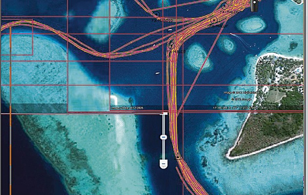
Cruising in remote tropical regions can be challenging, especially where there are no charts suitable for pilotage. Often the charts that do exist are old and inaccurate. To make matters worse, coral can grow surprisingly fast and what was a clear channel 20 years ago might now have coral heads just below the surface. Read More


Google EarthnavigationOpen CPNSAS.planet
Share Tweet

Administrator

You Might Also Like

  • Dock Talk

    In-Depth Guide to Building a Solar Charging System for Your Boat

  • Dock Talk

    Zoleo Provides the Simplest Satellite, Cellular and Wi-Fi Comms Worldwide

  • Dock Talk

    Mustang Introduces Award Winning Atlas PFD That Does It All

Recent Posts

  • Survey of the Week

    January 22, 2026
  • Mindbender

    January 22, 2026
  • ATN’s Gale Sail for Heavy Weather Sailing

    January 22, 2026

Please Visit Our Sponsor’s Webpages


  • Home
  • Media Advertising & Rates
  • Blue Water Sailing
  • Multihulls Today
  • Archives
  • Contact Us

Published by Blue Water Sailing Media, a division of Day Communications, Inc., Middletown, RI

Publisher & Editor: George Day

Blue Water Sailing Media publishes Blue Water Sailing magazine, Multihulls Today and other titles.

Cruising Compass Advertising Sales:

George Day, Newport, RI
george@bwsailing.com
401-847-7612


Recent Posts

  • Survey of the Week
  • Mindbender
  • ATN’s Gale Sail for Heavy Weather Sailing
  • Is Electric Propulsion Viable for Cruising Boats?
  • Elan Launches new Line of Luxury, High Tech Cruisers
  • Just Announced: Tartan Yachts Looks to Bright Future Under New Ownership
  • Survey of the Week

Search

© 2014 Blue Water Media. All rights reserved. | Admin