


Ducking out of cycone season’s path in the South Pacific doesn’t always mean heading for New Zealand (published May 2014)
It was time to leave the southern hemisphere’s cyclone season and tuck safely into a place free of dangerous weather. Our insurance policy demands it and it is a worry-free way of cruising. So where should we head? The traditional route from Fiji and the surrounding islands is to head to New Zealand. Last cyclone season, we did the Tonga to New Zealand route. But this season we decided to let our cruising friends head south as we headed north towards the equator. This path is the less popular route and it is probably because you get to face “Mother Nature’s moods.” You get the ITCZ, SPCZ, sea mounts and equatorial currents, all while using less than perfect charts. And you get to travel alone because you simply can’t talk your long-term cruising friends into coming this way, though we tried and tried.
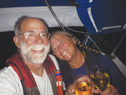
Our boat is a 1987 Moody 422 sloop named Astarte that we have cruised full-time on since February 2009 when we left St. Petersburg, Florida. There are two of us aboard and we call ourselves “comfortable” cruisers. We don’t push the boat hard and we sail the boat for safety, comfort and ease of handling, rather than speed.
Choosing a route north towards the equator would take us from Fiji to Tuvalu, onto Kiribati and finally ending in the Marshall Islands. The total distance is 1,759 miles, about 500 miles further than the Fiji to New Zealand non-stop run. Along the way we’d get our second equator crossing and visit some of the smallest independent countries in the world. We were certainly not the first to do this, but amongst our cruising group, we were the only ones considering the trip north. The route is becoming more popular, though, thanks to Google earth charts and the OpenCPN maps that have good coverage. Other cruisers have written excellent compendiums and blogs about this voyage. So after changing our minds multiple times, we decided on this passage.
September 9, 2013
Fiji to Tuvalu – 615 miles
Course: North
After clearing out from customs and immigration, we left Vuda Point on the western side of Fiji’s largest island, Viti Levu. We headed south to get through an easier reef cut and to make our way around two Fijian island chains. The weather forecast looked promising for the predicted five to six day passage. But we’ve quickly learned that the weather in this area is quite hard to predict thanks to the ever-changing, ever-moving SPCZ (South Pacific Convergence Zone) that settles in the vicinity of Tuvalu.
Once outside the reef, the wind was on the nose. We prefer not to burn fossil fuel by motoring, but we were still close to the outer reefs and wanted to give ourselves some sea room, so we motorsailed. The seas were confused making the ride uncomfortable, especially for that first day out. We had done short passages while in Fiji for the previous four months, but needed some time to get our sea legs back. As midnight approached, we were able to turn off the “steel drum band” and sail, though we were still hard on the wind.
September 10 – 13
(Friday the 13th), 2013
Climbing Sea Mounts
The Pacific has “sea mounts”—areas where the depths come from tens of thousands of feet to thousands of feet. There is no fear of hitting them and running aground, but with no land mass in the way, there is a lot of water being pushed against this “shallower” bottom creating big seas. The Hat Puk Sea Mount was on our route and rises from 14,000 feet to 2,000 feet and our intended course took us around the obstruction. But even though we were more than a mile off, we still experienced the confused seas.
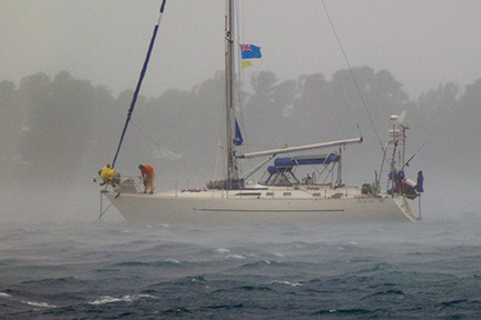
Since we entered the Pacific, this was our first long passage with the wind forward of our beam. Most of our ocean sailing had been downwind runs, and we were getting pretty good at that. Because of the westerly current, we pointed as high as possible to stay east making it a wet and wild ride. Waves consistently crashed over the bow and a few times our log read, “the cockpit got half-filled with a big wave.” We do a three-hour night watch system aboard Astarte and at shift change, it took time to un-layer the rain gear. Finding space below to hang wet clothes was a challenge and on this point of sail, we also discovered a few leaky ports below decks.
Consistent squalls meant we needed to reef and unreef the sails quite regularly in daylight and keep them shortened for the night watches. The rain came in regular intervals and the winds gusted as high as 35 knots. The good news was that we were making headway and putting miles under the keel.
On Friday, September 13th, we focused on how many miles were left to our destination of Funafuti, Tuvalu. We have a rule aboard Astarte to never enter a harbor at night. And with iffy charts, a fringing reef and a narrow passage, we definitely wanted decent light to get into this atoll. We planned on entering through the southwest passage, Te Ava Fuagea, rather than through the main southeast passage, Te Ava I Tu Puapua, as the winds had been blowing heavily for several days from the east and we did not want to negotiate a pass with waves behind us. We also hoped to make it there early enough on Saturday to avoid another night at sea.
Saturday, September 14
Entering the Lagoon
The seas flattened, our speed picked up and we had the low Funafuti Atoll in sight before 11 a.m. Timing would be perfect for a slack tide. Then the squalls came. One squall after another piled up and we lost sight of the island group. The winds howled, the rain bucketed down and we did circles just outside the passage. On our fourth try, we made it in with just enough light to see the reefs and maneuver through the narrow, doglegged pass. Unfortunately, by now, the tide had turned, so we battled an outgoing current and wind on the nose. Astarte struggled in the narrow part of the pass to make more than three knots.
Once inside the lagoon things calmed. We motored across the 10 by 13 mile lagoon avoiding coral patches to the anchorage. As we were setting anchor, another big squall came with gusts of close to 40 knots and a heavy downpour. Luckily the anchorage had good holding.
“Talofa” (“Hello”) to Tuvalu
08°31’.5 South / 179°11’.4 East
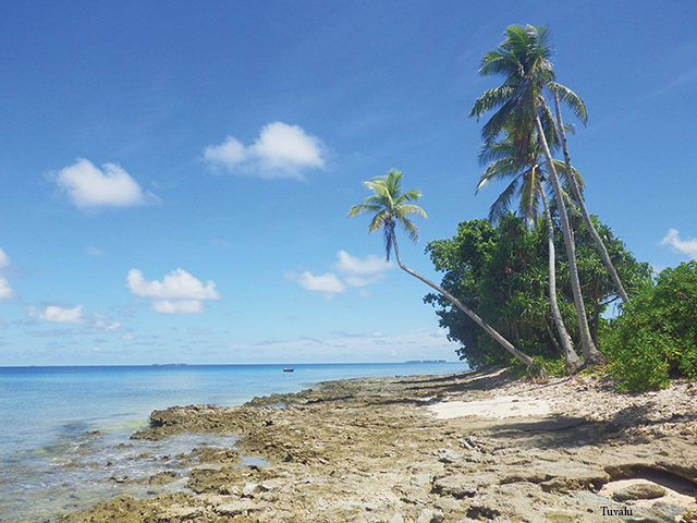
Tuvalu, formerly Ellice Island, is the second smallest nation in the world. It is an all atoll country (one of four), and made up of nine island groups, though the name Tuvalu means, “eight standing together.” Staying almost a month in the Funafuti Atoll turned out to be a truly enjoyable experience.
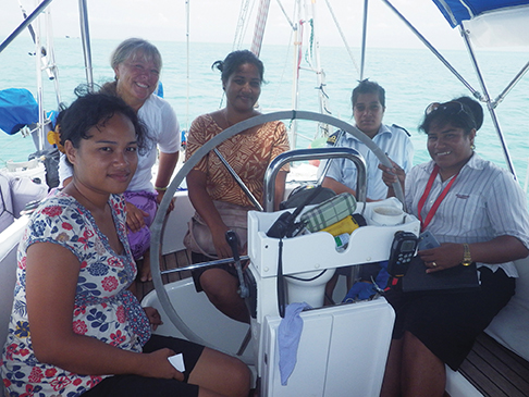
We remained aboard Astarte until Monday when we could legally clear into the country, which was convenient as we had lots of drying out to do. Clearing in to this small nation was a simple process, or it would have been, had Monday not been “clean-up day.” All the government offices were officially closed so everyone could help clean up the island. Not knowing this, we went ashore in search of customs and immigration, which are located on opposite ends of town. While waiting at the closed customs office, with no sign indicating why it was closed, the agent, clad in “clean-up clothes,” arrived at his office to get something. Even though the office was officially closed, he checked us in, but we’d have to wait until Tuesday for immigration.
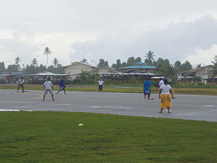
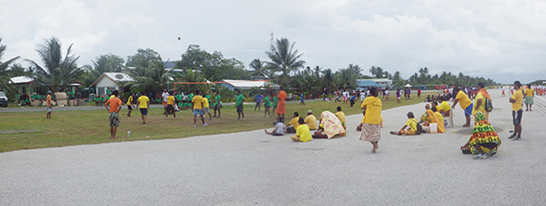
The island of Funafuti is a long narrow strip of land—you can actually see the ocean and lagoon at the same time. The international airport runs down the middle of the island and is where islanders gather to play sports, socialize and even sleep. Twice a week it gets cleared off by a fire truck so a plane can land. Our visit coincided with “trade fair week” and their 35th Independence Day celebration, which also lasted a week. So there were plenty of festivities, street food, music, sports and local dancing. The people were very friendly and welcoming.
When it was time to depart, the “Tuvalu meteorological service” provided us with a “customized” forecast for the next leg of our voyage. Because the SPCZ was moving right around the Tuvalu area and we were heading towards the ITCZ (Intertropical Convergence Zone), it was hard to predict whether we would have the doldrums or heavy winds and squalls. This ever-moving “blob” on the computer screen would literally be there one day and totally gone the next. Picking a weather window for departure became a challenge.
October 12 – October 23, 2013 Tuvalu to Kiribati
Distance – 745 miles
Course: NNW
We cleared out of Tuvalu for the 745 miles to Tarawa, Kiribati. The Tuvalu meteorological service and our GRIBS predicted a steady 12 to 15 knot east wind for the first few days—a nice beam reach to start. And no ugly lows or fronts were out there to collide with the constantly moving SPCZ. Because of the predicted light winds later in the week, we anticipated that this leg would take us more than eight days.
The reality was quite different than the prediction. We started out with very light wind from the north. The engine was on and off and the sails changed almost hourly as the winds came and went. But we ended up having some of our best sailing on this leg of the trip with a beautiful beam reach, going at times a steady 6.5 knots in relatively light winds and good seas. The bad news was that we were making little headway towards our destination. We tacked to keep the boat speed up and the ride comfortable, but we weren’t heading in the right direction. The weather was simply not cooperating. There would be big wind in squalls and then no wind at all. Sometimes we even went backwards thanks to an adverse current.
In this area there are several currents that impact your movement. There is the south equatorial current that heads westward at about one knot and follows close to the equator. There is the equatorial countercurrent that can run as high as two knots in an easterly direction and is just north of the equator. Over the course of this voyage, we felt the impact of both of these currents in speed, direction and sea conditions. The good news was that we weren’t getting waves over the bow.
We crossed the equator late on October 21. Though we were already “shellbacks,” it is still a special moment to go over the imaginary line that separates the hemispheres. Our crossing was late at night, but worthy of a toast to Neptune—photos and the dropping of our sealed champagne bottle with a note in it. And the bottle has already been located!
October 23, 2013
Tarawa, Kiribati
01° 22’.0 North and 172°55’.8 East
“Mauri” (hello in Kiribati)
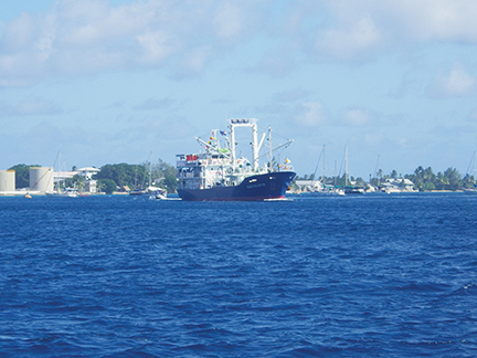
At 8:47 a.m. we dropped the anchor in Tarawa off Betio in Kiribati. The entrance to this harbor is well marked and dotted with giant fishing vessels. The passage took 11 days, and our log entries described a bit of everything. Flat seas. Big seas. Engine on. Engine off. Full sails. Reefed sails. Squalls. Sun. Wind from the north, northeast, east, southeast, south and even a bit of northwest. Thunder and lightning. Rainbows and sunsets. Ships heard and ships spotted. Boredom and excitement. It was a trip that had it all, and it took a long time.
After anchoring off the town of Betio, the boarding party of four women from customs, police, immigration and health were picked up. The clearance process was on board and efficient. Tarawa is a heavily populated island and supposedly more densely populated than Calcutta per square foot. The people are friendly and helpful. The anchorage of Betio has good holding, but is not very pleasant because of all the traffic, large fishing vessels, wrecks on the reef and dirty water. While in Kiribati, we spent most of our time anchored on the opposite side of the wharf near the Parliament House with cleaner water, less traffic and a convenient dinghy dock.
Kiribati, pronounced Kir-ee-bas and formerly known as the Gilbert Islands, is made up of three chains of atoll islands: the Gilberts, Phoenix and Line Islands. It covers a huge area of Pacific Ocean and is very hot because it straddles the equator. Tarawa is the sight of major World War II battles and the remnants of these fights can still be seen on the island in the form of rusting old shipwrecks, guns and gun emplacements. We couldn’t get permission to visit the outer islands without having to return (against the prevailing winds) to Tarawa to check out, so we only stayed 10 days. This is a place where getting to the outer islands would be desirable and we plan to stop back in Kiribati on our return trip south to explore the outer atolls.
November 2, 2013 – Tarawa, Kiribati to Majuro,
Marshall Islands
Distance – 390 miles
Direction: North/Northwest
This passage was shorter, though more impacted by adverse currents. Once outside the Tarawa channel, the engine went off and we were underway sailing with a full main and genoa. Day one was a great day of sailing making a steady 6 to 7 knots an hour—at least until 10 p.m. Then the wind just died and we motorsailed throughout the night.
We had a pleasant broad reach for a while thanks to the wind increasing to a nice east-southeast breeze of about 8 to 10 knots. But the seas grew more confused and the skies got dark and ominous. Mother Nature seemed mad and we were hit by squall after squall and some had that heavy, garden hose type rain. There were several fishing boats that moved in and out of our visibility and we sailed when we could, and motored when there was no wind. The seas and currents fought each other, turning our world into a washing machine. Though not easy, we crossed off the miles and spotted Majuro Atoll a long way off because of the brightly lit tuna ships in the harbor. It looked like a big city from a distance and we hurried to get there during normal business hours so we didn’t have to pay the costly overtime clearance fees.
Tuesday, November 5
“Iakwe” from Majuro in the
Republic of the Marshall Islands
07°06.4 North/ 171°22.0 East
We entered the atoll’s main entrance, which is well marked, at 10a.m. and made our way across the deep lagoon. This is a large atoll and we maneuvered around the huge fishing fleet to our booked mooring. We moored at 1p.m., inflated the dinghy and went ashore to check into country number 28 on our cruise. We are here for several months to sit out cyclone season, so we have plenty of time to see many of this country’s islands.
Why did we choose to sail the path less traveled?
Why not? We had already been to New Zealand, and the small island nations of Tuvalu and Kiribati intrigued us. Since leaving Florida in 2009, we had always followed the traditional sailing routes so we felt it was time for a change. And after doing a lot of refitting and repairs while in New Zealand during the previous cyclone season, Astarte was in good shape. Plus, New Zealand can get chilly during the summer and we like being in the water—the temperature of the ocean is perfect here! So we headed towards the equatorial chain where we now sit enjoying the tropical climate. We’ll explore many of the Marshall Islands and then who knows which “classic passage” we’ll try next. Whatever we decide, I’m sure we’ll change our mind a few times!
Barbara and Michael have cruised full-time aboard their Moody 422 Astarte, for five years putting more than 25,000 miles under the keel. Their passports have stamps from 28 water-bound countries so far. In their land lives, they were both in the television business where they traveled by air instead of water. They prefer traveling by water.