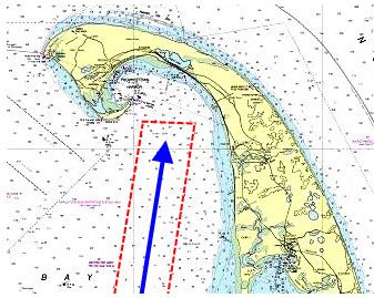
On a 1:80,000 scale coastal chart, use two or more nautical miles to form a “scan box” around the intended sailing track. Here, as we approach Provincetown on Cape Cod Bay, our sailing track (blue) has been surrounded by a lighter box (red) two miles wide on each side. Highlight dangers inside this area. See steps below.
This week Capt. John of skippertips.com helps us steer clear of wrecks.[spacer height=”10px”]
There are more than a dozen specific wreck symbols shown on charts used by mariners throughout the world. All of these are covered in detail later in this chapter, but the three we will discuss first are the foundation–or “brick ‘n mortar”–of all wreck symbols and abbreviations.
Indeed, these three wreck symbols dominate charts in both US and International waters. The first two look like a fishbone and the other resembles a half-submerged hull. I believe the easiest way to find these symbols and abbreviations begins with a fast sketch of your intended route.
Plot your intended sailing track line (also called “course line”). In the illustration above, the dark blue line represents our track line. Next, form a virtual “box” around that line that extends out to port, starboard and ahead of the track. This encloses the track to create a safety-zone to help account for leeway or steering errors (red dashed lines in illustration above).
Base the box size on the chart scale being used and the proximity of dangers in the specific area. For example, on a 1:80,000 scale coastal chart (illustration above), you might sketch a box two miles or more on each side.
Scan all inside the box you have just sketched. Highlight those symbols and abbreviations that may create a dangerous situation. Create GPS proximity waypoints, along with danger bearings or danger circles to insure safe passage (see “Related Articles” below for more on each of these sailing navigation techniques). Now let’s take a look at some of the most common wreck symbols.

If you see just a fish-bone symbol without dots (far left illustration), this means the wreck will be safe to cross.You can draw a sailing course line across bare fish-bones all day long without worry. Note the two fishbone symbols southwest of lighted buoy “PP”.
Cartographers place these onto charts to warn large ships or commercial fishing vessels to take extra care. Ships anchor with hundreds of feet of chain, so these deep sea wrecks could foul an anchor.
If the big ship anchor gets stuck inside a wreck, the ship might find it impossible to weigh (pull in) their anchor. And huge commercial fishing trawlers sometimes drag their nets along the seabed.
These deep water wrecks could snag a net. This could cause great danger and “trip” the fishing vessel (capsize it). Or the fishing vessel skipper would have to cut away the net, costing him or her tens of thousands of dollars in lost gear and equipment.
Detour Around These Dotted Wrecks!
Look for fishbone symbols enclosed by dots (middle illustration). Dots around a wreck always indicate danger. These wrecks are close enough to the surface to threaten all vessels.
Note the dangerous wreck to the north has no description. All parts of this dangerous wreck will stay below the sea surface, even at low tide. Look at the dangerous wreck to the south and you see the abbreviation “Mast” in slanted letters has been placed next to the wreck symbol.
This wreck will show just its mast above the sea surface at low water. Look in the title block of your nautical chart (the summary of information located beneath or near the chart title) to find the low water datum specified for your nautical or electronic chart.
Beware of Half-Hulls at the Surface
Stay far away from black hull symbols (far right illustration). These wrecks show their deadly heads just above the surface at low water datum (in some cases you will not see these until you are on top of them). Half-hull symbols (Ajax Reef) signal a serious hazard. Stay well clear to avoid catastrophe!
Note the slanted abbreviation “PA” next to the wreck. This means “Position Approximate“. This wreck could shift position in storms, tidal surge or in high winds. Note the small open circle with the vertical letters “pile” nearby. Vertical letters tell you the this pile should be visible, even at high tide.