And without better detail, the entry could prove to be a tough challenge indeed. Take a look at one of the unique “two for one” benefits you can receive on some nautical charts.
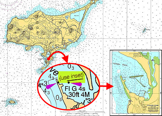
It’s best to start a passage plan with a smaller scale chart that encompasses the sailing area and approaches. Here we have a chart off the south coast of Alaska.
Our intentions are to anchor (or tie up if anchorages are not available) in Village Cove on the south side. We have looked in our chart catalog for a larger scale chart that gives details on the shoals, aids to navigation and general topography of the cove. But, none exists.
Look just inside the area of Village Cove and you can see the chart note that says “See Inset”. Some chart makers save lots of time and money when they insert large scale chartlets onto the smaller scale chart.
And sailors save money because there will be no purchase a separate larger scale chart for entering a tight harbor or anchorage. Of course, this will not always be the case. But insets are a big benefit to “grab ‘n hold” if you find these on any nautical chart.
Once you see a note that indicates an inset exists, look to the chart corners. Here, the inset has been embedded into the lower right corner. Now let’s use this inset to plan a safe entry into Village Cove that will serve us by day or by night.
How to Use an Inset to Enter a Harbor
Use the same amount of care to annotate, label and highlight a chart inset. Once you sail on to the inset of a chart, you will have no time for the finer points of navigation. Take the time now to complete 90% of your navigation for an easier, safer entry.
. See more below.")
Highlight and annotate your inset just as you would the important features on the main chart body. Courses would also be plotted (not shown to avoid clutter on this reduced graphic of the actual inset). See more below.
Our inset will be on a 1:5000 scale, perfect for close quarters navigation. As you might recall, the smaller the second number of the ratio, the greater the detail of the cartography. Soundings on the inset are in fathoms (1 fathom = 6 feet); soundings less than 11 fathoms are indicated in fathoms and feet (the sub-scripted number shows the remainder of feet).
We will enter between two lights that mark the outermost breakwall and breakwater. Both of these foundations are surrounded by Rip Rap. Light 3 to port shows a flashing green four second characteristic; light 4 to starboard shows a flashing red four second characteristic. A lone dolphin (similar to a piling) will be visible just past light 4 to starboard.
Primary shoals less than one fathom are on the port side as we enter so we will favor the starboard side. We will set up two danger bearings. Let’s set up our first danger bearing with Light 3. We run a bearing line along the edge of the two fathom curve, which will provide a margin of safety for keel clearance. Our first danger bearing will be Not Less Than (NLT) 325° Magnetic.
You will shoot this bearing “over the shoulder”, or behind you. Note how Light 3 will be aft of the boat once you enter Village Cove. Use a handbearing compass. Turn around and take bearings to the light after you sail past. Make sure that those bearings read 325°M or higher at all times.
You will have good protection from wind or swell except from the north-northwest. If winds are expected to shift to the northern quadrant, tying up would be a better option than anchoring. You might be able to tie up behind the first breakwater to the south next to the boat ramp (note the “Ramp” between the two breakwaters).
Let’s find another aid to navigation to help us stay in safe water if we need to sail to the boat ramp. We can use Light 6 (flashing red every 2.5 seconds) on the end of the far breakwater as a danger bearing. Plot a bearing line along the edge of the two fathom curve. Our second danger bearing will be Not Greater Than (NGT) 090° Magnetic.
We would also plot and label two courses onto the inset. One would be the entrance course to take you from between lights 3 and 4 to the turn to the boat ramp. The second course would take you into the vicinity of the boat ramp. In the illustration, these are not shown to reduce clutter (the actual inset is much larger than the illustration).
Check the predicted time and height of high and low water. Will your draft allow safe passage on the approach and alongside the Ramp? Annotate and highlight your inset just as you would the main chart body. Choose colors that will stand out day or night (and not disappear under a red or blue night light).
*IMPORTANT NOTE: All illustrations used on this site in any form of content, including compass courses and bearings, are for training purposes only.
They should not be used for navigation. Use the latest edition nautical chart that has been corrected and updated for safe navigation aboard your boat.