• Home
  • Cruising Compass Media Advertising & Rates
  • Blue Water Sailing
  • Multihulls Today
  • Contact Us
  • Subscribe Today
Cruising Compass
Dock Talk 0

Google Maps Goes Coastal with Unmanned Boat

By Administrator · On August 6, 2015

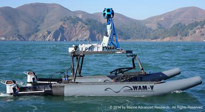
A new high-tech unmanned vessel, launched with the help of Google, will use innovative technologies from the boatbuilding and mapping fields to map shorelines and raise awareness of the impacts of global sea level rise.

Originally designed to be worn by backpackers, Google’s proprietary Street View Trekker camera system was provided on loan to the San Francisco Baykeeper organization, allowing them to create bay-level maps.

Electric motor developer Torqeedo said it was chosen to power the craft as clean, powerful and efficient propulsion was a high priority.

Read More

Google MapsUnmanned boat
Share Tweet

Administrator

You Might Also Like

  • Dock Talk

    Mindbender

  • Dock Talk

    Survey of the Week

  • Dock Talk

    Cruising in the Time of War

Recent Posts

  • Safety at Sea Experts Investigate Yacht to Yacht Rescues

    March 19, 2026
  • Mindbender

    March 18, 2026
  • Survey of the Week

    March 18, 2026

Please Visit Our Sponsor’s Webpages


  • Home
  • Media Advertising & Rates
  • Blue Water Sailing
  • Multihulls Today
  • Archives
  • Contact Us

Published by Blue Water Sailing Media, a division of Day Communications, Inc., Middletown, RI

Publisher & Editor: George Day

Blue Water Sailing Media publishes Blue Water Sailing magazine, Multihulls Today and other titles.

Cruising Compass Advertising Sales:

George Day, Newport, RI
george@bwsailing.com
401-847-7612


Recent Posts

  • Safety at Sea Experts Investigate Yacht to Yacht Rescues
  • Mindbender
  • Survey of the Week
  • Mindbender
  • Survey of the Week
  • Update on Indian Ocean Crossings This Spring
  • Survey of the Week

Search

© 2014 Blue Water Media. All rights reserved. | Admin