


How to safely negotiate atolls of the South Pacific (published May 2013)
By now, every cruiser has certainly heard of the Tuamotus, a string of low-lying Pacific atolls straddling the central section of French Polynesia. Although the wonders of GPS have “downgraded” the Tuamotus from their status as “the Dangerous Archipelago,” enough obstacles remain to give many cruisers misgivings—and rightly so. For many, the Tuamotus represent a first encounter with narrow passes and coral-strewn lagoons where landmarks are practically non-existent and eyeball navigation is the name of the game.
So just how easy, or how dangerous, are the Tuamotus? You won’t know until you get there. That’s why we recommend that newcomers master the basics of atoll navigation at the most accessible, “tamer” Tuamotus first, and then graduate to more challenging atolls after gaining first-hand experience. It’s a matter of piecing together an irregular puzzle of reefs, passes, anchoring techniques and weather patterns. Ultimately, a brief sampler of the Tuamotus proves to be enough for some cruisers; others move on to the greater challenges and rewards of atolls further off the beaten path.
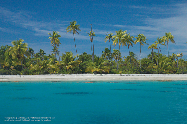
The sprawling archipelago’s 77 atolls are made up of large fringing reefs marked by a few tiny islets (motus) that barely rise above sea level. Within each atoll is a relatively calm lagoon littered with unmarked coral heads. The only things abundantly available in these watery oases are coconuts, fish and pearls. Fresh water, provisions and fuel, on the other hand, are all hard to come by, so cruisers must be as self-sufficient as they would be for a long offshore passage.
GATEWAYS TO THE TUAMOTUS
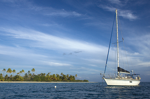
The two most-traveled gateways to the Tuamotus are Rangiroa, at the northwestern edge of the group, and Fakarava, at roughly the central point of the chain. Each of these atolls feature wide, well-marked passes that even cruise ships can enter, with easy-to-follow channels inside. Naturally, these user-friendly passes mean that Rangiroa and Fakarava are the atolls most impacted by outside influences in terms of both culture and environment. On the other hand, both offer relative safety and peace of mind, making for a balanced trade-off.
Rangiroa lies on a direct line from the Marquesas to Tahiti and therefore makes a natural stopping point for many westbound sailors, especially those on a tight schedule. This atoll is so vast (the second-largest in the world) that you can build an entire cruising itinerary within its sea-like lagoon. For this reason, some make Rangiroa their one and only stop in the archipelago before continuing on to Tahiti. Others add in neighboring Ahe, which likewise promises a straightforward pass and easily accessible lagoon anchorage. Fakarava, a centrally located atoll within the archipelago, calls for only a minor deviation off the direct line from the Marquesas to Tahiti, and is also a logical stopping point for sailors arriving via the less-traveled Gambier Islands. Next door to Fakarava is lovely Toau, population two. This atoll is the perfect second step along a natural progression through the archipelago.
RUNNING THE PASSES
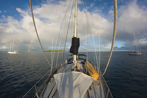
In pre-GPS days, sailors avoided the Tuamotus for fear that the slightest navigational error might put them high and dry on a reef. Nowadays, navigation to and among the atolls is generally straightforward. The first real challenge cruisers face is entering an atoll. Happily, the main passes into both Rangiroa and Fakarava are not only clearly marked, but extremely deep and wide as well. However, timing is everything. Throughout the atolls, you must plan your entry and exit carefully and use the prevailing southeasterly winds to your advantage. Avoid strong contrary tides—peaking at 5 knots or more in some passes—as well as strong wind-against-tide situations. The best time to enter a pass is at slack tide, even if that means waiting. After all, sailing is a game of patience. Of course, there are a few exceptions to this rule. For example, passes located on the leeward side of an atoll may be cautiously attempted at the tail end of an outgoing tide (in other words, against the wind and a weak tide). Conversely, windward passes may be transited with a weak incoming tide. Unfortunately, the tide tables incorporated into some chart plotting programs are inaccurate for this region, giving many sailors a nasty surprise. We used the French SHOM tide tables instead and found these to be extremely reliable (see resources sidebar).
Another factor to take into account when entering a pass is the sea state. Because the southern and western sides of the atolls are usually very low, seas will break over the reefs after a period of strong, sustained winds from a southerly or westerly direction, or if a southerly swell of more than six feet has been running for some days. All the water pushed into the lagoon this way will flood out through the atoll’s passes, causing an enhanced outgoing and a weakened incoming tidal stream. This effect will also delay, or even eliminate, the low water slack tide while advancing the high water slack tide by an hour or two. Ultimately, you should calculate the window of opportunity as best you can then carefully observe pass conditions upon approaching. If in doubt, use VHF channel 16 to contact boats anchored inside the lagoon or to reach a local dive operator for advice. Don’t be put off by a bit of uncertainty; the atolls will repay your patience many times over.
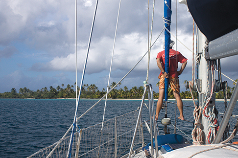
At oft-traveled passes like those in Rangiroa and Fakarava, there is absolutely no need to send someone aloft to eyeball the route ahead. We saw one sloop crashing its way into Fakarava’s north pass in a wind-against-tide situation with one crewmember perched up in the spreaders for “safety.” How the poor man kept from being launched overboard as the sloop pitched and slammed wildly was a mystery. It’s far better to wait for a favorable tide and save the second-story acrobatics for unmarked passes in other atolls—at slack tide, mind you!
Once through Tiputu Pass in Rangiroa, it’s a simple matter of sailing directly to the nearest village anchorage. In Fakarava, running the north pass and navigating the main channel is straightforward thanks to excellent markers. Assuming the sun is high in the sky, isolated coral heads are easily distinguishable as shallow green or brown patches against the darker blues of deep water. In fact, newcomers will quickly realize that markers are largely superfluous in fair weather. Conversely, cloudy skies or low sunlight will make coral heads much harder to spot. At the same time, crewmembers must keep an eye out for the small buoys that mark pearl farms inside the lagoons. These are lessons that one can quickly learn in the tamer Tuamotus before navigating unmarked sections of the main lagoons or in atolls off the main byways.
ANCHORING IN THE ATOLLS
When safely inside an atoll, sailors can head for a tantalizing, isolated motu of their very own, even in relatively populous Rangiroa and Fakarava. But there’s one last hurdle: anchoring, which presents two sub-challenges. First, finding a well-protected spot behind the low-lying, tiny islets of the atolls can be like trying to hide an elephant behind a telephone pole. As soon as the wind shifts, you are likely to have to move—a major effort in large atolls, where traversing from one side to the other can be an all-day effort, and where fetch can create considerable seas. When looking for a good spot, keep in mind that though the wind can blow from any direction, you should be especially wary of the powerful southerly winds, called mara’amu.
The second challenge of atoll anchoring is keeping your ground tackle from wrapping around coral heads (bommies), since it is rare to find a broad enough sandy patch to accommodate your entire scope. The solution is to “float” your chain with fenders set at intervals of roughly one to one and a half times the depth. When the chain is not under load, the fenders will suspend it above bommies as the boat drifts from side to side. Anchoring in 20 feet of water, for example, set your first fender at about 30 feet, the second at 60 feet, and a third at 90 feet. Just keep in mind that a perfect set will take some adjusting after you snorkel to observe how the chain behaves. The greatest threat comes from bommies close to the boat, which can catch the chain and shorten the scope. Exactly what you don’t need when a squall suddenly kicks up.
WEATHER
Conditions in the Tuamotus can change rapidly, so it is critical to track weather developments carefully using all the resources at your disposal. Weather systems moving east from New Zealand and tracking south of French Polynesia may work in concert with the South Pacific Convergence Zone (SPCZ) to disturb the trade winds and cause squally conditions and wind shifts—critical information in choosing your anchorage. Therefore, the prudent cruiser should monitor weather forecasts that provide some measure of atmospheric instability as well as describing general trends. In our experience, NOAA’s GRIB files sometimes indicated very light winds when in fact gusts of up to thirty knots occurred. We therefore augmented use of the GRIBs with a number of additional sources, such as Meteo France text forecasts, NOAA weather charts (particularly Lifted Index found in their Spot forecasts), and NADI Fleet Codes (see details in resources sidebar). As at sea, our SSB and Pactor Modem proved to be indispensable tools for receiving meteorological information.
ENJOYING THE ATOLLS
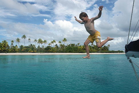
As far as we’re concerned, the atolls are a place to enjoy solitude rather than sample village culture. However, the main settlements in Fakarava (population 1,000) and Rangiroa (3,000) do offer the advantages of Internet, small shops and dive outfitters who can shuttle SCUBA enthusiasts to some of the most spectacular dive locations in the world. One notable site is Fakarava’s legendary South Pass, where dozens, even hundreds, of sharks feast on the multi-course meal the currents sweep past, a particularly action-packed scene during full moon phases. Not every venture into the water has to be an exhilarating thrill as there is also the pure serenity of snorkeling off your boat in idyllic green-blue shallows.
Many sailors find that their thirst for atoll living is quenched after one or two stops in the Tuamotus. Some find the experience nerve-wracking, especially when unsettled weather demonstrates just how exposed the anchorages really are. Other sailors can’t get enough of this paradise and linger an entire season in the archipelago. They revel in largely untouched atolls such as Makemo, Kauehi and Raroia. Ultimately, the length of time sailors devote to cruising the Tuamotus depends as much on their ability to tolerate the challenges as on their luck with weather. Outside time pressures also conspire to interrupt the reveries of some cruisers, who have to hurry to Tahiti to meet scheduled guests. Air Tahiti Nui offers regular flights between Tahiti and many of the atolls, so you might ask visitors to book last minute connecting flights to the Tuamotus rather than rushing away from this unique location.
Are the Tuamotus truly dangerous? Given a fair degree of prudence, no. On our 1981 Dufour 35 with a six-foot draft, we use GPS as well as paper and computer charts, but don’t have a chartplotter, and we never needed the radar. We did use our SSB radio and Pactor Modem to download weather information daily. Consequently, we were able to keep a step ahead of unpleasant conditions and truly enjoy the magic of the Tuamotus. What’s to keep you from doing the same?
Nadine Slavinski is the author of the book Lesson Plans Ahoy: Hands-On Learning for Sailing Children and Home Schooling Sailors. Currently on sabbatical from teaching, she cruises aboard her 35-foot sloop, Namani, with her husband and young son. They are currently in New Zealand and looking forward to new Pacific landfalls. Her website, www.sailkidsed.net lists free resources for home schooling sailors.
WEATHER AND TIDE RESOURCES
The Tuamotus lie within the French Polynesian time zone: UTC-10.
Accurate tide tables can be downloaded from the French Hydrographic Office (SHOM) at http://www.shom.fr/ann_marees/cgibin/predit_ext/choixp?opt=&zone=8&port=0&date=&heure=&portsel=map.
There are several weather forecasts available for the archipelago:
Meteo France issues both marine and land forecasts. The forecasts are available from www.meteo.pf or on request from Saildocs (send an email to query@saildocs.com with no header and the message “send fr.poly”). Of course, these forecasts are in French, but the basic vocabulary is easy to decipher.
NOAA Spot Forecasts detail a number of useful weather parameters. Request by sending an email to query@saildocs.com with an arbitrary subject line and the following message body: “send Spot:16.1S,145.7W|7,3|PRMSL,WIND,WAVES,RAIN,LFTX” (without quotes). This example requests a 7 day forecast at 3 hour intervals (“|7,3|”) for the location 16°06’S 145°42’W (“16.1S,145.7W”), including sea level pressure (“PRMSL”), average wind speed and direction (“WIND”), significant wave height, swell direction and period (“WAVES”), precipitation (“RAIN”), and Lifted Index (“LFTX”, a measure of instability in the atmosphere). You can alter each data point as needed, keeping in mind that positions must be specified in decimal degrees (rather than minutes) to one decimal point.
NADI Fleet Codes are synoptic charts issued by Fiji’s meteorological service that cover the southwest Pacific. Send a message to query@saildocs.com with “send fleet.nadi” in the message body (without quotes) or “subscribe fleet.nadi” for a 14-day subscription with daily delivery. To display these fleet codes as synoptic charts, you will need a free, small software application called PhysPlot (see http://www.pangolin.co.nz/physplot).
SPOTLIGHT ON FAKARAVA AND TOAU
Fakarava is a perfect location to learn the lessons of “Atoll Cruising 101” because one long, thin motu shelters the entire east coast, with a marked channel leading several miles away from the small-scale “development” of Rotoava village. Atoll novices will be relieved to discover there is nothing life threatening about leaving the channel and finding a place to anchor. With the sun high overhead, it’s easy to pick your way through coral heads to sandy patches 15 to 30 feet deep. Even though Fakarava draws a fair number of sailors, it is possible to find your own anchorage. That is, if the copycats don’t find you. Often, we were happily enjoying our solitude until the magnet effect drew in a handful of other boats. Perhaps they reasoned that we had found “the” anchorage, when in reality, they could have strung themselves out almost anywhere along the shoreline.
From Fakarava, it’s a pleasant day sail to Toau. On the northwest side of this atoll, two distinctive white range markers lead the way into Anse Aymot. This is a false pass that breaches through the fringing reef of the atoll without breaking all the way through to the inner lagoon. The result is a mini lagoon with excellent 350° protection—a rarity in the Tuamotus. In Toau, one friendly couple lives off the bounty of the land and sea, occasionally offering evening meals at an open-air “restaurant” by the shore. However, they are extremely busy with multiple atoll pursuits and may not be able to offer regulars meals. Consider it a treat, not a given. They have even set up several moorings (a herculean effort involving repeated free dives to depths of fifty feet and more) to eliminate the hassle of anchoring over coral heads (not to mention the damage this inflicts). Some cruisers linger for weeks in this unhurried place, snorkeling the reefs and wandering the wild, tangled edges of the motus.