


Mahina Tiare‘s crew settles in for a journey south along the U.S. Pacific coast (published February 2017)
March 23, 0115 hrs, 44.53 N,
124.38 W, Log: 180,947 miles
Baro: 1010.1, Cabin Temp: 66 F (furnace is on low), Cockpit: 50 F, Sea Water: 55 F
Close-hauled at 5-6 kts under double reefed main and triple reefed genoa in 20-28 kt S headwinds and occasional squalls.
A ROUGH AND WET START TO OUR 25TH SEASON
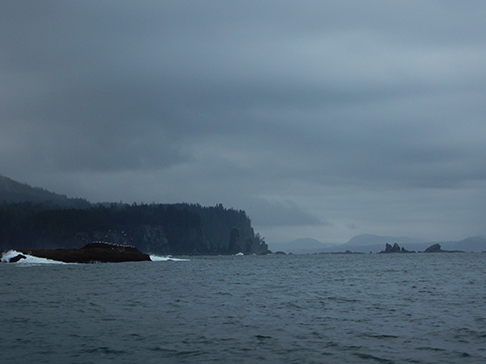
We were 31 miles northwest of Newport, Oregon, reefed down so we didn’t arrive at the Yaquina River bar entrance before dawn or before the strong ebb tidal current, which can cause breakers across the channel entrance, had subsided.
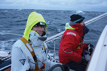
 Our keen and eager crew joined us for this passage Thursday, March 19th in Victoria, Canada. I say keen and eager, since why but for heavy weather experience would anyone sign up to sail down the Washington-Oregon coast so early in the season? Our personal reason for setting off in March instead of June is simple: to be able to sail to and then clear of the Caribbean before the start of hurricane season in early July.
Mahina Tiare wintered ashore on Vancouver Island 20 miles north of Victoria at Canoe Cove. Amanda and I arrived March 8 to complete a few chores which included anti-fouling (just around the waterline) along with getting professional help with a couple of engine and rigging projects. Two days later we set sail for Roche Harbor Resort where we loaded all the gear we’d been stockpiling over the winter and set about completing our outfitting over the next week. It was then off to Victoria where we tackled the few last-minute jobs in between our final provisioning runs.
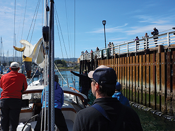
 We were ready when crew arrived on March 19th and within 30 minutes of their arrival we’d set sail in a light fog 24 miles directly south across the Strait of Juan de Fuca. Our mission was to clear U.S. Customs in Port Angeles, WA and here we found an excellent marina, a very helpful harbormaster and friendly efficient customs officers.
It was 55 miles to Neah Bay, the small Indian settlement on the northwest tip of Washington State, so we got underway just before first light on a dark wet morning. It was afternoon before the rain tapered off and the following easterly winds picked up, and pick up they did, with MT surfing along at over 8 knots before we stopped to practice Lifesling overboard rescue in the gusty conditions.
It was tipping buckets when we reached Makah Marina, owned and operated by the Makah Indian tribe. Dave rigged the cockpit enclosure, we cranked our trusty Webasto furnace on high and before long our adventuresome crew took off exploring the settlement, rain or no rain. For the first time in our three visits the impressive tribal museum was open and Amanda and I enjoyed a quick tour before closing time.
The requested forecast we received from Commanders Weather was not at all promising: they suggested we wait in Neah Bay until later in the coming week to avoid a quick procession of fairly active frontal passages bringing southerly headwinds. By listening to the local VHF continuous weather broadcasts and looking at the GRIB weather charts, we determined the winds along the coast to 10 miles off were consistently 5-to-10 knots less than in the 10-to-60-mile offshore region. We decided to head out on another first light departure and on rounding Tatoosh Island motorsailed south in light headwinds along Washington’s dramatic and rugged coast.
Now underway we chose to start with small goals—our first was just to make it to the bar entrance at Grays Harbor. On passing Grays Harbor, our next thought was making it to the Columbia River bar entrance and into the port of Astoria, Oregon, hopefully just before near gale force headwinds picked up. Very early in the morning, the forecast improved so we elected to bypass Astoria. Our mission was to make the next port of Newport, Oregon, again a river bar entrance, before yet another frontal passage with forecasted 30-plus knot southerly headwinds arrived. Actually, the first front passed us. We kept reefing the main and rolling up more headsail and our trusty crew enjoyed the challenge of motor sailing in difficult, chilly wet conditions.
The Coast Guard was making frequent broadcasts on Ch. 16 announcing that all of the harbor entrances, including the Columbia River bar, were now closed to vessels under 40 feet, due to breaking wave conditions when the ebb current hit the westerly swell. As maximum ebb today was at 0800, we purposefully tacked 35 miles offshore so we wouldn’t arrive until closer to the time of slack water.
Surprisingly we didn’t see a single fishing boat, and other than ship traffic at the entrance to the Straits of Juan de Fuca and off the Columbia River the only other vessel we saw was a motor yacht heading north.
March 25, 2015, 2335 hrs, 41.37 N, 124.59 W, Log: 181,201 miles
Baro: 1027.2, Cabin Temp: 68 F (furnace is on low), Cockpit: 49 F, Sea Water: 57 F
Broad reaching at 4-5 kts under full main and genoa in 10-12 kt N following winds and seas.
WHAT A DIFFERENCE A DAY MAKES, AND HOORAY, WE’RE NOW IN CALIFORNIA
 We hove-to for 30 minutes just outside Newport, Oregon’s entrance channel to wait for slack water, and via cell phone received a recorded bar report, plus we spoke with a Coast Guard watchstander. The officer was extremely helpful stating that since we’d waited for slack water we would miss the 10 foot breakers in the channel and should have passable conditions, noting that the bar remained closed to all vessels under 40 feet due to hazardous conditions.
As the strong west winds would be directly astern, we elected to drop the main but leave a small amount of headsail up for stability and in case we lost power. We again all reviewed the full-sized paper chart of the harbor entrance, the C-MAP chart running on Rose Point Coastal Explorer, the Navionics chart running on our Raymarine C80 MFD plus the directions, chartlets and aerial photos in Don and Reanne Douglass’ excellent Exploring the Pacific Coast cruising guide.
Dave skillfully piloted us in the narrow channel lined with rock breakwaters and had his hands full keeping MT lined up on the leading marks especially when a whale surfaced beside us, sea lions leaped in the waves and a crab pot buoy danced precisely mid channel. Several times it looked like breakers were about to crash over our stern but MT rose with the crests before surfing dramatically forward.
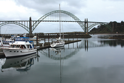
After a few minutes we got into calmer water, passed under the Highway 101 classic bridge and began looking for a fuel dock. A helpful liveaboard cruiser who worked for the Port of Newport Marina gave us a hand tying up, welcomed us to Newport and woke up the fuel dock attendant.
Our crew set off for showers, then a hike across the bridge to explore the town while Amanda and I went to work on unblocking a head, changing engine oil and compiling a shopping list. By the time we were ready to head to town it was blowing a hoolie with a downpour to match so we hitched a ride to the grocery store where everyone was talking about the 60-knot southerly storm forecasted for the evening. Once back aboard we doubled up the mooring lines enjoyed an amazing dinner then all crashed, barely hearing the howling in the rigging and the torrential rain that occurred through the night.
March 27, 2015, 0411 hrs, 39.10 N, 124.04 W, Log: 181,367 miles
Baro: 1022.0, Cabin Temp: 64 F (furnace is on low), Cockpit: 49 F, Sea Water: 56.8 F
Broad reaching at 5 kts under full main and reefed genoa in 10-12 kt N following winds and moderate seas.
 Yesterday morning, we departed at slack water with much mellower bar conditions although sadly, the forecasted 10-to-15 knot northwesterly conditions never arrived. Instead we had headwinds of up to 27 knots all night and through to the morning when it finally abated, shifting to the southwest, west and now northwest.
This afternoon, right on cue, the sun came out as we crossed the border into California and we gained a brief escort as a mother grey whale and her calf surfaced close off the bow. As we were now 35 miles west of Klamath River and in 3,000 fathoms of water, we no longer had to keep a lookout for crab pot floats which was nerve racking, particularly at night.
 We’re not sure where our next stop will be, possibly Santa Cruz or Monterey and for now we’re pleased to have clear skies, lots of stars and following wind and seas allowing us to catch up on sleep and turn our attention to class and learning.
MYSTERY SHIP
For the past 24 hours we’ve had varying levels of fog with visibility ranging from .2 to 4 miles, so we’ve been running our 48 mile Raymarine radar and AIS transceiver continuously with someone responsible for watching it. Around midnight Amanda started tracking a radar return not transmitting an AIS identifying signal. It matched our 5-knot speed and was on a parallel course four miles further offshore.
After relieving Amanda a few hours later, I called the vessel, using the cursor on our MFD display to identify their position, stating I was concerned that they were slowly cutting across our course. On the second call, “Warship 1” faintly replied, stating that they were the vessel I was concerned about. Their radio signal was weak and their radar image was so small, what one would expect from a 50-foot fishing vessel at four miles, not from a warship, so I asked them to confirm that they were in fact 15 miles northwest of Point Arena. They confirmed this was so, then slowly speeded up, their radar return completely disappearing at six miles. If this truly was a warship they were obviously using a form of stealth technology.
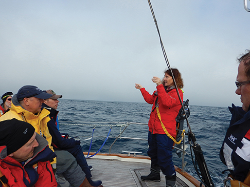
Today our favorable following northerly winds gusted into the mid-30’s giving our watchstanders some excellent surfing experience as we zoomed along at up to 9.5 knots. The swells were amazingly modest and Amanda was able to complete a very thorough rig inspection and spares class, followed by my in-depth start to our marine weather class.
Most of our crew enjoyed hot showers on the aft deck and we are all pleased and excited to have strengthening northerly winds forecasted for the next several days. An overnight stop in Monterey on Saturday was definitely a strong possibility and it was a great relief, for the first time in three similar expeditions, not to be concerned about having enough time to reach San Diego before the final day of the expedition. We were even talking about a night anchored off Hearst Castle at San Simeon Bay.
March 30, 0115 hrs, 44.53 N,
124.38 W, Log: 180,947 miles
Baro: 1010.1, Cabin Temp: 66 F (furnace is on low), Cockpit: 50 F, Sea Water: 55 F
Close-hauled at 5-6 kts under double reefed main and triple reefed genoa in 20-28 kt S headwinds and occasional squalls.
AWESOME DOWNWIND SAILING IN SUNNY CALIFORNIA AND DAMAGE FROM A WHALE?
A ridge of high pressure off the California coast has meant that every day our downwind sailing conditions have been a little stronger than the previous day, frequently reaching the high 30-knot and low 40-knot range. We’ve covered hundreds of miles with reefs in the main and just a scrap of genoa all the while surfing along and at times reaching over 9 knots in seas up to 14 feet. It certainly gave our crew fantastic steering, reefing and jibing experience.
Last night was particularly rough with large, confused following seas and sometime after dinner several of us heard a large THUD, like someone had dropped-closed an open deck hatch lid. Early this morning Greg pointed out that our second port stanchion, from the bow, was severely bent inward at nearly a 90-degree angle. I checked it out and discovered black tissue flakes scattered about the stanchion, surrounding deck and dinghy. There was no sign of contact on the hull topsides, only the bent stanchion. Bizarre, but not dissimilar from last September in Alaska when a humpback whale, concentrating on chasing a herring ball, didn’t see MT until the last minute when it made a sudden 90 degree turn, rolling over its feeding partner and nearly whacking the inflatable kayak lashed to MT’s lifelines with its pectoral fin. We’ll never know what hit us this time but fortunately we have a spare stanchion to replace the bent one.
 Originally, we were concerned about reaching Monterey before dark and spent the majority of the early afternoon motoring when the wind went light but in the end we had to slow down so as not to arrive too early Saturday morning. Navigating through the fog, we found the municipal marina (located next to Monterey’s historic Cannery Row) very helpful on the phone and when we checked into their office. We’d arrived on an 82-degree cloudless (ashore but not out to sea) Saturday morning at the start of spring break so the wharf was lined with families fishing, the pier a mass of wandering shoppers and seated diners, and the beaches packed with families and water craft.
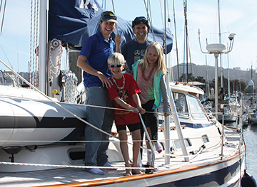 Minutes after our arrival our crew headed off on their own adventures and when Amanda and I had just about completed inventorying our provisions someone from the dock hailed “Hello Mahina Tiare”. We popped up to discover Alison, NASA astronaut candidate and rocket scientist extraordinaire and Leg 3 expedition member, with her husband Glen and 8 and 10 year olds, Paul and Clair. They’re planning to set sail on their own cruising adventures to Australia next year and earlier Alison had emailed saying that if we stopped in San Francisco she would REALLY, REALLY like to show her kids the boat she’ll be sailing to Panama on.
It worked perfectly—Alison got to show her family MT and in exchange she kindly offered to run us to the nearest grocery store while Glen took the kids to a huge public playground/park next door. Amanda chose Safeway over Trader Joe’s and Alison certainly helped us power shop while plying us with questions of the boats she and Glen are considering. As we were loading the groceries into the back of the wagon I asked Alison what all the wetsuits were for. She said that in case the marina was full and we were assigned a mooring buoy they planned to rent kayaks and paddle out to visit. This is one determined girl!
Deryk had calculated it was a 90-mile run to San Simeon, the bay that Hearst Castle overlooks, so that dictated yet another pre-dawn departure. Amazingly, everyone was up on deck and ready to go at 0500 and we crept along, following a fishing boat, out into the dark through the crowded mooring field. Thankfully there was no fog or too many crab floats and we were soon sailing smoothly south.
April 3, 2015, 0115 hrs, 32.59 N, 117.45 W, Log: 181,907 miles
Baro: 1015.4, Cabin Temp: 67 F (no more furnace!), Cockpit: 30 F, Sea Water: 67 F
Motoring along quietly at 6.6 kts in 5 kt NNE winds.
ROUNDING POINT CONCEPTION
Who says it never blows in Southern California? Only occasionally did we shake the third reef out and last night was a challenging one as we dodged oil platforms, moored and drifting oil tankers, all the time trying to stay clear of the Vessel Traffic System lanes. Coast Guard broadcasts were forecasting gale warnings with 35 knot winds, gusting to 45 knots, and seas to 15 feet for the rest of the week, but only north and further offshore once we round Point Conception and head for Santa Catalina Island.
 Our strong northwest following winds and seas held until we were a few hours from our 0400 arrival at Two Harbors, Catalina Island, giving us enough time under power to nearly top up the batteries. Our original plan had been to continue on to Avalon, the busy little seaside tourist town of Catalina Island, but we were nearly a day ahead of schedule, thanks to the fresh NW winds, so we decided to explore Two Harbors, an isolated settlement with numerous sheltered bays and coves, most having mooring balls.
Entrance in the dark proved easy, thanks to the excellent level of detail provided on C-MAP charts running on Rose Point Navigations Coastal Explorer program on our laptop temporarily located in the cockpit. With a couple hundred empty moorings to choose from our expedition members did a brilliant job of picking up and securing the connected bow and stern moorings. Then it was very quiet. In the nearly full moonlight we could see tall palm trees lining the beach.
We all headed ashore to explore this lovely spot after breakfast. The spine of Catalina is rugged and dry and as Amanda and I hiked east along the coastal track we met a very sweaty Deryk who showed us on a map how he’d nearly circumnavigated half the 18-mile-long island.
Dave took the watch as Amanda taught splicing on the trip to Avalon, where we secured to an assigned mooring and headed ashore for a hearty Italian dinner. The next morning Jacqueline was the only taker for a sunrise run up the mountains and following breakfast Amanda taught sail repair and use of our Sailrite sewing machine before I covered communication options. Crew headed ashore for more hiking and exploring and to celebrate Tara’s birthday and we met on the dinghy dock at 1900, getting underway for San Diego while there was still light to maneuver clear of the 250 moorings.
April 8, 2015, 0625 hrs, 32.42 N, 117.13 W, Log: 181,949 miles
Baro: 1016.8, Cabin Temp: 64 F, Cockpit: 65 F, Sea Water: 67 F (warmer!)
Moored at Kona Kai Marina.
 Our dawn arrival was uneventful and after breakfast we completed our teaching with going aloft, cruising medicine, celestial navigation, braid splicing and whipping. We enjoyed an excellent graduation dinner ashore with three previous expedition members joining us and before long Leg 1 crew were off to new adventures.
John Neal’s 342,000 offshore miles include six Cape Horn roundings plus voyages to Antarctica and Spitsbergen. Since 1976, John’s passion has been sharing his knowledge of ocean cruising and he has conducted more than 170 sail-training expeditions worldwide aboard Mahina Tiare III, a Hallberg-Rassy 46. When not at sea, John and Amanda are based on San Juan Island, www.mahina.com.