


Vanuatu by Sail (published October 2017)
Since we left Panama and started sailing west across the Pacific it has felt like we were twenty years too late. Paddles had been abandoned for outboards, dugout canoes had been replaced by sleek fiberglass skiffs. Few were the opportunities to trade and those who did offer fruit wanted whiskey and cigarettes in exchange. Familiar fast food logos lined the streets of the larger cities we stopped at, plastic wrappers and soft drink cans littered the paths of the small villages we visited. It felt like the pristine beaches and plentiful fish were all but gone, now it was all about the digital age and tinned corned beef. But there was one place I was still holding out hope for; Vanuatu.
Vanuatu had been on my radar for years as a place that was wild and free. Heck, just saying the name out loud – Vanuatu – sounded exotic. Vanuatu was the place where we could stand on the edge of an active volcano and watch dugongs frolic around the boat. The place where people worshipped Cargo cults and wealth was measured by the curl of a pig’s tusk.
However, the season we were finally ready to depart Fiji, Vanuatu was suddenly on everyone’s radar. We watched from afar as tropical cyclone Pam, a category 5 storm, made landfall, and international headlines in March, 2015. Thanks to modern weather predicting and public service warnings reaching the outer islands via the mobile phone network, human casualties were low, but the devastation to property, crops and the landscape was high.
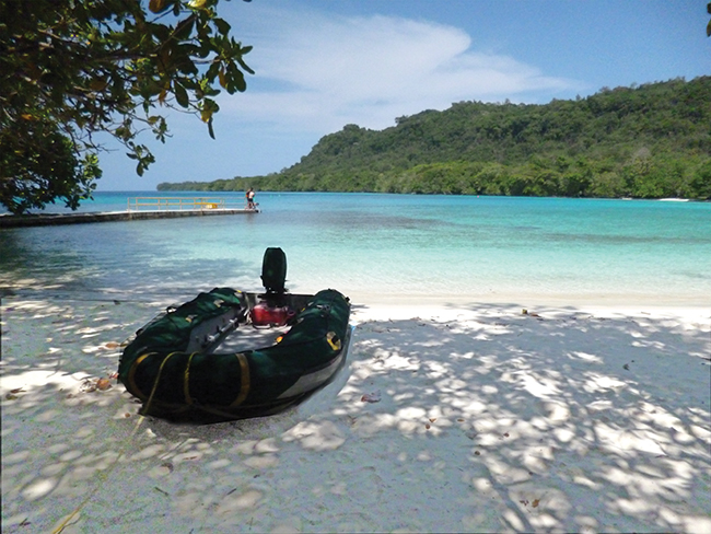
Not wanting to arrive and burden already taxed resources, we diverted to New Caledonia for six weeks. After three days of beating into 25 knot winds we were making our final approach to the island of Efate, and Port Vila Harbour. We had it on good authority that the harbor was well marked because of frequent cruise ship traffic but we weren’t sure what would be left standing after Pam. The afternoon light was already buttery yellow and the shadows on deck long, but arriving after dark is never a good plan and what worried us most was what new hazards may be lying in wait. We decided to spend the night in the slowly shoaling Mele Bay, just around the corner from the main harbor. We arrived well after sunset, the flashing lights and thumping stereo ashore guiding us into the bay.
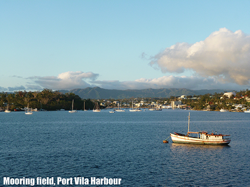 The next morning, we motored into Port Vila Harbour and threw the anchor down by the yellow quarantine buoy. Although the channel markers were still afloat it was obvious that Pam had pummelled the town. Despite a massive salvage effort there were still boats washed up on shore near the main mooring field. The quaint thatch-roofed villas of a ritzy harborfront resort now looked like a shanty town. The town’s concrete seawall had been smashed, rebar and rock exposed, the pedestrian path behind it riddled with ankle twisting holes where it hadn’t been completely washed away. Yet, for the locals, cyclone Pam was old news, the routine of everyday life had already gotten back into full swing.
When the Customs and Quarantine Officials came out to the boat for our inbound clearance there was little talk of the storm. Expecting the usual laid-back island-style check in we were surprised how formal and efficient the clearance procedure in Vanuatu were. With cruise ships arriving up to five times a week the officials are switched on about proper procedures and expect visiting yachts to comply. Vessels are required to anchor in the quarantine area with the yellow ‘Q’ flag raised, notify officials of arrival via radio and remain on board until they visit the boat. They even prefer that you give advanced notice of arrival via their website, https://customsinlandrevenue.gov.vu/index.php/en/travellers/yacht-clearance. After Customs finished their inspection and gave us the all clear we were expected to find the Immigration office ashore, pay our fees and get our passports stamped.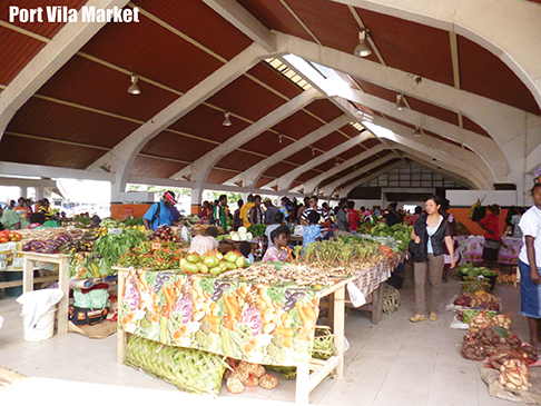
Port Vila is a welcoming but bustling city; a far cry from the rustic outpost that I was expecting. The town itself is built along the sprawling waterfront with numerous sidewalk cafes, restaurants and bars vying for your tastebud’s attention. Home to the only international airport in the island group and with a large, deep harbor that easily accommodates cruise ships it is the tourism hub for the country. Influenced by both the French and British, who co-governed the country together for decades, it has a unique cosmopolitan vibe.
Anchoring in the city can be difficult, the deep harbor shoals quickly and the holding in the shallow spots is not great. Yachting World, www.yachtingworld-vanuatu.com, offers moorings handy to all the action, however as Pam proved this is not a place to weather any major storms. Port Vila Boatyard, www.portvilaboatyard.com, across the harbor in Pontoon Bay, is a small but well-appointed yard that offers moorings a little further away from town. They also offer haul out and hard stand services, including safe, long-term storage for the cyclone season. This is also the home of the Vanuatu Cruising Yacht Club and sponsors of Vanuatu’s National Junior Sailing Team, a fun spot to watch the local kids dart about the bay in their dinghies.
City life wears thin for us after a week or two, even in a place like Port Vila. The holds were full and our batteries were recharged. After ample testing of Vanuatu’s famous Tusker beer, it was time to turn our bow south.
TANNA
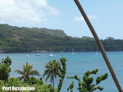 Our trip to Tanna was not the easy overnighter we had hoped for. Hampered by fierce counter currents and light winds we tacked and struggled for almost two days without making much progress. We finally sought shelter on the western side of Erromango for a night. Although the bay was exposed to the swell we caught up on some much-needed rest and reassessed our sail strategy. After another rather cold and wet night at sea we pulled into Port Resolution at day break, under the watchful eye of Mt.Yasur and those in the anchorage with their binoculars out.
We dropped anchor at the back of the pack and settled in. Over the next few days we saw a parade of boats coming and going, many using Tanna as a pit stop on their way to Australia or NZ for storm season. Although Port Resolution was once an official port of entry, clearance is now done in the capital of Lenakel, on the more exposed western side of the island.
Arrangements can be made to bring officials over land, for a fee, but many forego formalities.
Like most of the island the Port Resolution Yacht Club was badly damaged by the cyclone. All that was left of the few cabins they had were cement slabs and PVC pipework. The club house was still standing but it was little more than a convenient meeting place when arranging tours with the caretaker, Werry. There was no cold beer to enjoy the stunning view with. However, like most people who sail to Tanna, we came to look at the volcano, not the anchorage.
 We checked the weather report and arranged transportation to the volcano with Werry. Although hiring a guide is not necessary, you can walk up to the rim of Mt.Yasur in your thongs, we thought it sensible to go with someone who was familiar with the mountain and its personality. Stanley, a friendly local came highly recommended. We piled into the back of Werry’s pickup truck and headed off across the island.
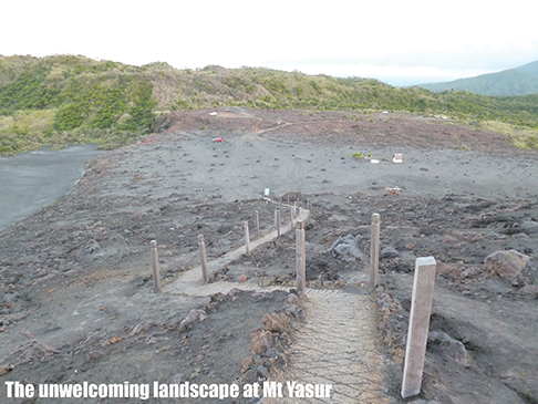
The main road on Tanna is really just two well-worn grooves of hard-packed dirt that snake around the island. As we drove great clouds of dust rose and swirled behind us and young boys on horseback followed in our wake, racing through the forest to show off their famous bareback riding skills. At the base of the mountain the road turned into two narrow paths of concrete blocks laid parallel to each other, like misplaced sidewalks in the jungle. Between the concrete the land was deeply eroded from the storm. The truck swayed and pitched over the rough road but our driver never misplaced a wheel.
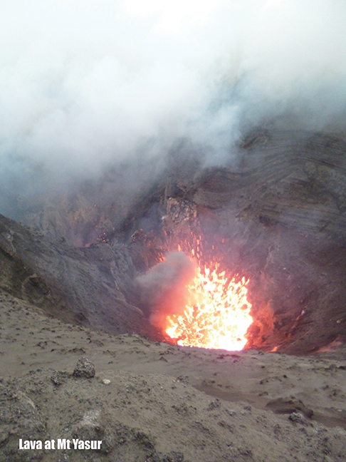
When we finally arrived on the ash plain the sun was low and the long shadows felt cold. Climbing out of the Hilux I turned to survey the stark and dusty terrain. A fresh breeze whipped around us, picking up sprays of dust and carrying the harsh, acidic scent of the volcano. I pulled up the zipper of my thin jumper and turned my back to the setting sun. This was not a welcoming landscape. I wasn’t the only one who seemed affected by our arrival. Stanley, who had always seemed warm and good humored, was now reticent about our expedition. Standing on the edge of an active volcano was something the “whitefella” thought was a good idea; the locals had a fearful respect for the fire breathing hole in the earth.
 We climbed the concrete path that was devoid of warning signs, safety tips and in most places a handrail and marveled at the spectacle that is nothing short of a natural wonder. The volcano rumbled like a freight train belching clouds of acrid steam. Waves of lava smashed together with metallic crashes and molten rock oozed from the vent only 100 meters below our feet. As the sun set the mountain awoke and the best fireworks in the South Pacific began. Magma spewed like a fountain and bits of red-hot lava rose into the dark night like sparks from a fire. That night we went to sleep with the glow of Mt.Yasur still visible in the sky above the anchorage debating if we should return for another viewing, after all our ticket stub did say the second visit would be 50% off.
EFATE
We returned to Efate to stock up before we sailed further north. Provisioning here is easy, if a little expensive. There are several supermarkets in town and with a large ex-pat community on the island they carry a variety of harder to find items. Vanuatu is known throughout the South Pacific for its tasty, high quality beef but it is only sold in the supermarkets and butcher shops in the larger towns, so don’t miss out.
The public market, the place to find fresh fruits and veggies, is a spacious open-air building nestled into the heart of downtown and is a hive of activity day and night. The handicraft market next door is the largest in the islands and worth venturing into. High quality crafts are sent from the surrounding islands to be sold here, however cruise ship tourism is a mainstay, so quality and price can vary. It pays to have a good look around and ask questions.
Outside the main harbor, and away from the busyness of town, there are only a few options for anchoring in Efate. Mele Bay, where we stayed on our first night, has excellent holding along a stretch of dark sand beach. You can get a cold beer and a meal ashore and the beach is a popular local swimming spot. However, it is open to the southeast so when there is a heavy swell you either put up with living in a washing machine or put out a stern anchor.
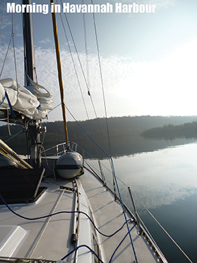 Just a few hours away, on the western side of the island, is the large and well-protected Havannah Harbour. Used as a navy base during World War II Havannah Harbour is now home to a few upscale resorts and restaurants. There are several anchoring possibilities but most of the large bay is quite deep. We found a very sheltered cove with good holding in the northern corner, a good spot to sit out a few days of disagreeable winds. As we approached the anchorage we noticed a large twin-masted boat lying on a distant shore, a perfect afternoon diversion.
After settling Kate, we jumped in the dinghy and as we neared the wreck we both remarked how familiar the boat looked. Vanuatu is well known for its shipwrecks but neither of us expected to find a piece of our history high and dry on the beach. There, where she landed when her anchors fouled in the height of cyclone Pam, was the very boat that Steve and I met on. I sailed on her from Thailand to Darwin, my first ocean crossing, learning the ropes and falling in love. It had been more than a decade since I had seen her and this was far from the reunion I expected.
After a few days our weather window opened again and we sailed north. With a string of islands close together we were able to day hop from anchorage to anchorage, even with light winds. Emae and Epi were just stepping stones, although comfortable anchorages. We were excited to get reach Malekula, in hopes of spotting some dugongs.
MALEKULA
The Maskelyne Islands are a small sub group crowded on the southeast tip of the large island of Malekula. With clear water and few people, it is a haven for these shy but playful sirens. In fact, the Gaspard Bay Conservation Area is one of the few places in the world that offer canoe trips and snorkel tours where you can sight and swim with dugongs. Anchoring in the long, skinny bay is permitted so we threw the hook and waited.
It didn’t take long before we were surrounded. Curious noses surfaced, sniffing out the strangers only to quickly dive into murky water if we made the slightest motion. A mother and calf ventured close to the boat between feeding on the sea grass beds that line the bay. Steve and I slipped into the dinghy and drifted towards the shallows trying to get a better view, but even our silent presence seemed to disturb them. I snapped a few pictures of rounded backs and their funny pig-shaped snouts but they proved too allusive to be caught on film. Still, sharing an anchorage with a dozen dugongs isn’t something we’ll soon forget.
Further up the island we found refuge in the large protected bay at Port Sandwich, a favorite stop among yachties. Like most of our time outside the major centers we were the only boat in the bay. Due to the local slaughterhouse dumping carcasses in the bay the sharks in the area are aggressive. In fact, our cruising guides tell a story of a little girl on a yacht who was killed when swimming off the pier we were anchored next to. We avoided snorkeling the reef or cooling off with an afternoon swim.
 Instead we took long walks ashore where we found a friendly community actively involved in the dying copra trade. Dilapidated drying ovens still squatted below the old growth coconut plantations and the tell-tale scent of slightly rancid coconut laced the air. Although the price of copra has fallen so dramatically that it is hardly worth the work, for many in the islands it is their only source of income. The day after the copra ship pulled out of town so did we.
AMBRYM
Thanks to the still active twin volcanoes on Ambrym the sand in the anchorage was some of the blackest I’ve seen. Black sand makes for a great holding as almost no coral can thrive in the acidic environment but standing on the bow as we entered the harbor I couldn’t define the bottom, judge depths or see hazards. Like so many other anchorages in Vanuatu despite arriving with good light I felt disoriented.
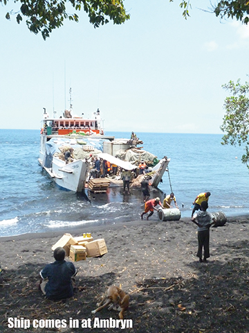 The next morning when we went ashore the sand was already scorching hot. Pulling the dinghy up the beach beyond the high tide line is usually punishment enough, but here it felt like we are walking on embers. Heat radiated off the sandy dirt track as we walked around the village, which is a hive of activity as the inter-island ferry/supply ship was due to arrive. We took a seat in the shade and watched as the barge ‘docked’ at the beach and the supplies were carried off. Fuel drums, roofing iron, tinned food, pigs, people; the beach was a blur of movement and the whole village had come out to watch. Although this is the kind of show we usually like to catch – the comings and goings of everyday life – there was another performance that we came to Ambrym to see; a ROM dance.
ROM dances, part of the ritual celebration for circumcision, are only performed high in the hills of Ambrym, where kastom practices still inform daily life and the traditional costume for men is the nambas (a woven leaf penis sheath). We had been on the island a few days before we managed to find a local named Obid who offered to arrange the dance with the village and was willing to be our guide.
We had picked up enough Bislama, the strange French/English pidgin spoken in Vanuatu, that when we arranged for Obid to come by the boat at 0830 the following morning we thought we were all on the same page. Of course, 0830 came and went. As did 0930 and then 1000. We didn’t exactly need a guide, the path up the incredibly steep hill was well worn and often traveled, but we did require someone to make the introductions, to vouch for us while we were in the village, so to speak. When he finally showed up just after 1030, somewhat apologetic but with the well-worn excuse of island time, we couldn’t say much. We set out on our hike on black sand under the midday sun.
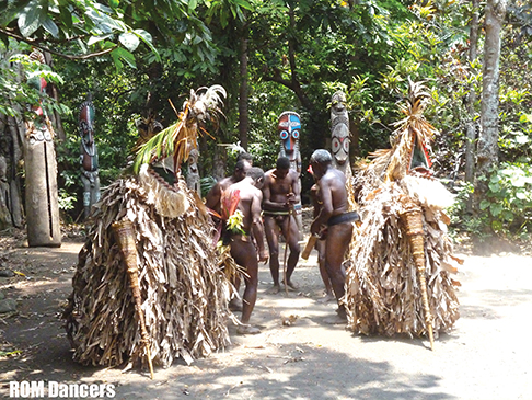 Our journey ended in a small, compact village high on the hills overlooking the anchorage. There in a clearing surrounded by slit drums carved out of tree trunks the men danced and sang for their audience of two. As the dancer chanted and kicked up clouds of dust I was invited to take photos. I have always been drawn to the rhythms of drums and curious about the customs of other cultures so I wasn’t shy about getting up to get a closer look, a better angle.
The lines between the sexes are well defined in Vanuatu, although the complexity of the relationships between men and women is not one I understood. When I asked questions about the meaning of the dance I quickly recognised that this was a ceremony for men and that much of the ritual was taboo for local women; they cannot be present when the costumes are being made nor are they allowed touch them afterwards. As a foreigner I was an exception, not completely bound by local law, but my “whitefella lady” status would only take me so far. I was still a woman. My camera was my talisman, I would have to be happy with a few photos of the world of kastom and black magic.
ESPIRITU SANTO
By the time we reached Espiritu Santo, or just Santo as the locals call it, it was November. The land was burnt brown and the streets were grimy, it had not rained since cyclone Pam battered the islands in March. Making headlines in the local newspaper were cases of small children and cattle dying of malnutrition and dehydration. There was talk of water restrictions in the major towns. Yet again we were glad to have a watermaker on board, we wouldn’t have to steal from the already strained water supply.
Luganville, the capital, is a small but busy town with a decent hardware store, post office, ATM and several general stores and cafes. We found a surprising variety of imported goods at the supermarket in town and took the chance to stock up one last time. I heard advertisements on the radio for a butcher shop in town run by a Kiwi guy. We found Paradise Meats, a clean and well supplied shop, next to the public market. I placed a large order and they were happy to portion, cryovac and freeze it all within a day; we would be eating delicious Vanuatu beef for the next several weeks.
Although Sola, Vanua Lava another 100 nautical miles north is an official Port we were warned by Customs in Efate that harbor fees are easier paid in the busy commercial harbor of Luganville. With only a few days left on our visas we did our outbound clearance in Luganville and asked permission to make a few stops as we sailed north. The officials were happy and later so were we. Our first day in the Solomon Islands we met a boat that cleared out of Sola but were not given the proper exit documents. They had their passports seized and had difficulty sorting the matter out with Solomon Island officials.
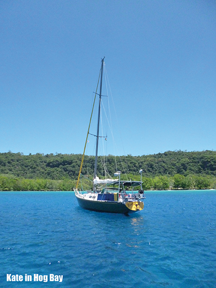
With our paperwork in order we set sail, only to be met by some unpredicted headwinds and a nasty looking sky. We ditched at Hog Bay, 36 nautical miles northeast of Luganville, hoping that the weather would clear overnight. Tucked in out of the breeze we found crystal clear water and a sandy bottom. A stretch of white sand and a manicured lawn beckoned us ashore, we hoped the resort served cold beer.
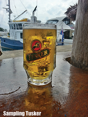 We sat with our toes in the hot sand and an icy cold Tusker in our hand looking out over the anchorage. Neither of us needed to be convinced to stay, at least for another day. We snorkeled with sea turtles, walked along sandy beaches and relaxed in the shade. Our chance stop at Hog Bay would turn out to be one of our favorite anchorages in all Vanuatu; calm, quiet and picturesque, but it wouldn’t be our last.
BANKS ISLANDS
We pulled into Sola, Vanua Lava in the Banks Islands under reefed sails and a grey sky. Having saved a few Vatu notes we went ashore to wander the quiet town in hopes of finding some fresh fruit or eggs for our passage. There wasn’t much to be had. Although the island was far enough north to avoid feeling the effects of Pam the drought was still wreaking havoc with the crops. A small shop had bananas so we stopped to buy a bunch and chat with the elderly woman behind the counter. Upon finding out that we were visiting by boat she turned and disappeared out the back of the shop. She returned with a choko, a small cabbage and a handful of tomatoes which she packed into our bag and insisted that we take as a gift.
 As we walked back down the dusty road towards the anchorage, the children running towards us smiling and the old men waving at us from the shade, I tried to soak it all in. It took us six years to get here and now the pending cyclone season was pushing northward, but I wasn’t quite ready to go. After six months exploring the islands this would be our last few moments in Vanuatu.
It may not have been the wild and savage country that I have been searching for, the truth is I don’t think those places exist any longer, but Vanuatu will always be a special place to us. We were overwhelmed not because we stood on the edge of a volcano but because the Ni-Van people showed us their kindness, generosity and resilient spirits. They shared their islands, their culture and their hearts with us, and in doing so touched ours.
Heather Francis is originally from Nova Scotia, Canada and Steve is Victoria born, Queensland bred. They met on a boat in Thailand. In 2008 they bought Kate, a Newport 41’, in southern California and have been sailing her full-time since. They are currently in the Philippines and are planning to do a lap around the planet, albeit slowly. To follow their adventure, log on to www.yachtkate.com.
WAYPOINTS
**To be used as reference only**
Mele Bay, Efate 17°41.62 S, 168°15.69 E
Port Vila Harbour, Efate 17°44.27 S, 168°18.59 E
Havannah Harbour, Efate 17°33.01 S, 168°17.02 E
Potnarin, Erromango 18°49.57 S, 169°12.51 E
Port Resolution, Tanna 19°31.48 S, 169°29.72 E
Emae Anchorage 17°02.72 S, 168°22.13 E
Epi Anchorage 16°35.65 S, 168°09.70 E
Gaspard Bay, Malekula 16°28.50 S, 167°49.23 E
Port Sandwich, Malekula 16°26.41 S, 167°47.05 E
Ambrym Anchorage 16°09.08 S, 168°06.45 E
Luganville, Espiritu Santo 15°32.20 S, 167°10.85 E
Hog Bay, Espiritu Santo 15°07.99 S, 167°06.93 E
Sola, Vanua Lava 13°52.40 S, 167°33.20 E
Rice, sugar, cloth, clothes, reading glasses and school supplies for kids are welcome trade items in the outer islands where supply ships are infrequent. Bislama, the lingua franca, in Vanuatu is a mix of French and English pidgin that is easy to learn and handy to know. Download audio lessons for free on the Peace Corp website and start learning today! www.livelingua.com/project/peace-corps/Bislama/. There are several cruising guides for Vanuatu. We like the interactive www.cruising-vanuatu.com, and found lots of handy info in the free guide at vwww.vanuatucruising.info. Both cruising guides work offline.
Kastom is the Bislama/pidgin word that describes the traditional religious and cultural values and practices in Melanesian society. Kastom beliefs pre-date the colonial era and often include aspects of magic.