


From the Scottish mainland to the far reaches of the Outer Hebrides, they discover a world seldom seen by sailors (published July 2015)
When we arrived in Scotland, to sail our boat (an Island Packet 380), Touché to the Outer Hebrides, we were met with the mountains fully carpeted by the “Blue bell of Scotland”. It was gorgeous! We quickly sorted out the boat, provisioned and then immediately set sail from Oban down through the Sound of Luing, into Loch Craignish and spent a few days in Ardfern. When we left, we timed our entrance to the infamous Corryvreckan perfectly. There was no wind or swell, so it was quiet like a mill pond.
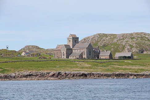
The Corryvreckan has a fearsome reputation because of strong tidal streams. In adverse weather—wind over tide—and with a swell running, it is said there may be four meter tall standing waves and crazy overfalls so sailors are strongly advised to stay away. We stayed overnight in the ‘secret’ anchorage “Bagh Gleann nam Muc” (also known as the Bay of Pigs) and the next day we had a glorious, sunny sail past the island of Iona, which boasts a cathedral and a monastery dating back to the 6th century from whence Christianity was introduced to the Picts and the Scots.
We also passed the small Isle of Staffa, with Fingal’s Cave, where Felix Mendelssohn is said to have been inspired to write his overture The Hebrides in 1829. The cave is an opening into the hexagonal basalt columns, which make up the entire island. However, we had already been there the year before so we headed to a wonderfully protected anchorage, called Gometra harbor, and enjoyed a beautiful tranquil evening.
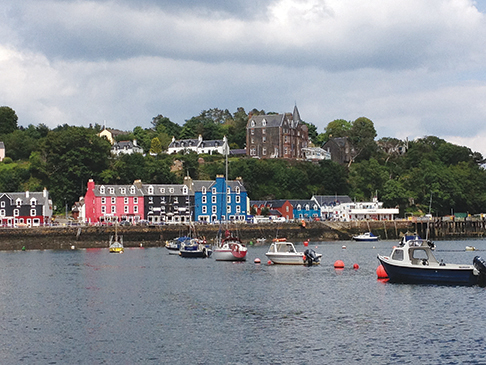
We had planned to make a stop at Tiree and from there sail to Barra Island in the southern end of the Outer Hebrides. Unfortunately, our windlass had chewed up the rope-to-chain splice so we had to return to Ardfern to have that fixed. There were no places in the Outer Hebrides where we could fix that. We had to sail back through the Corryvreckan, this time accompanied by dolphins and in absolutely benign conditions. Meanwhile, the weather window closed, so after our repairs we sailed up along the Isle of Mull to Tobermory. Tobermory is a small town with colorful houses and a delightful whisky distillery, well worth visiting, so the change in plans wasn’t completely bad.
Next, we rounded Ardnamurchan Point, where you are supposed to tie a bouquet of heather to your pulpit, as the rounding is considered a feat since the tides and waves can be challenging here, as well. Conditions weren’t bad, but we had a long slog to windward against waves and the last of the tide. After the rounding, we had a beautiful beam reach past the small isles: Muck, Eigg, Rum and Canna. We were aiming for the Isle of Skye, where we happen to know of a small whisky distillery, making a very limited edition of whiskies using original Gaelic recipes.
ISLE OF SKYE AND ISLE OF RONA
Rona has a very secure and picturesque natural anchorage where we enjoyed a nice evening watching the birds and the red deer on the hillside. The island has a very interesting ancient cave, which was used for Sunday worship until a church was built in 1912. The cave has rows of flat stone seats in front of a stone altar and even a small baptismal font that was surrounded by ferns. The path to the church was well marked, but it was a tough track across a moor, ending in a steep descent into the cave with just a rope to hang onto. I kept thinking of the guidebooks description: “It’s not easy, but grannies used to do it”. But, I bet that rope wasn’t there then.
The next day gave us a blustery sail in full sun—wind behind the beam— past “the old man of Storr” and across the northernmost tip of Skye, with beautiful views all the way to the Shiant Islands.
We had planned to stop at Ardmore Point, just around the Vaternish Peninsula. But the wind had freshened considerably and there was no place to anchor. There was a ruined chapel on shore we wanted to see so we just caught a buoy for the night at Stein. The harbor was not well sheltered so we got up and left early the next morning for the Outer Hebrides.
STORNOWAY AND THE OUTER HEBRIDES
We often wondered how Scotland got the reputation for rainy and awful weather. We had another day with full sun and a clear blue sky. What a glorious sail. We decided against going around the Shiant Islands and went into Stornoway, where we lay alongside as boat number two at low tide, next to the high pier. It was going to blow a bit, so we stayed a few nights in Stornoway and caught a bus to view the Callanish Stones (a larger and older version of Stonehenge). We walked from there to the Doune Broch (another amazing stonework) and ended up at Gearrannan, a black house open air museum and finally the next bus took us back to the boat.
After a day of laundry and stocking up we went south along the chain of the islands that make up the Outer Hebrides. Our goal was Eriskay and Barra (with appropriate stops along the way).
ERISKAY AND WHISKEY GALORE
Eriskay Sound is the resting place of the wreck of the infamous S.S. Politician, which you can see beneath the surface in quiet weather at low tide. The S.S. Politician went aground on a foggy night in 1941 on its way to Jamaica and sank with more than 28,000 cases of whisky at a time when the islands were completely out of the local product. The story of the wreck and the looting of it were made into a book and a movie called Whisky Galore. To this day, a bottle or two occasionally surfaces from hiding places ashore or even from the sand around the wreck. Sadly, it is completely undrinkable.
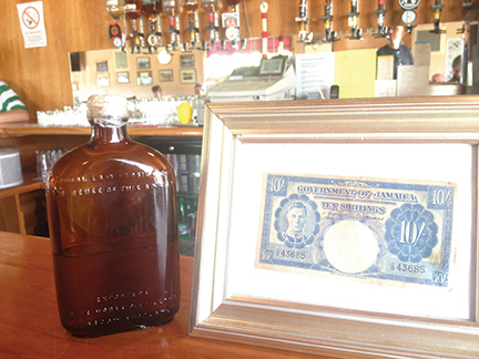
However, when we got to the wreck, the tide was running and we had a bit of wind. We went back and forth over the spot of the wreck and we’re pretty sure we caught its shadow on the GoPro, held under water. A gale was forecast, so we decided to stay in the extremely well sheltered Arcaidsaid Mhor—another perfect natural harbor. These islands seem to have them everywhere. Of course, we had to go to the pub, named after the wreck, where lots of memorabilia is on display, including three original bottles and 10 shilling Jamaican notes, also found in the wreck.
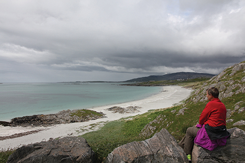
The island, like the others in the chain, is absolutely beautiful. The machair (fertile grassy plains) was in full bloom, and the island was fringed with fantastic white beaches and turquoise waters. If you do not venture into the 57° F water, you could almost be fooled into believing you were in a much warmer climate. One beach is called Prince Charlie’s beach, famous for being where Bonnie Prince Charlie landed from exile in France in 1745 during the second Jacobite rising.
We anchored in Castle Bay on the Isle of Barra, picked up crew at the tiny airport, whose runways are on the white cockle beach. It is said to be the cleanest airport in the world as the runways gets washed twice a day with the flooding tides. Thus, the flight schedules are synche’d to the tides.
Anchored off Vatersay, we were treated to two large dolphins showing off and the next day we were in complete solitude at Mingulay, an island now deserted. We polished off the Southern Isles of the Outer Hebrides by rounding Barra Head, which is the southernmost point.
ST. KILDA
British sailors have a destination, which is sort of a holy grail: To sail to St Kilda. It is a tiny island, about 45 miles further west of the Outer Hebrides and only has one small anchorage, which requires stable weather and very little swell. The guidebooks warn, “It is essential to clear out should the wind come from between east and south” and “do not delay going ashore, as the weather may change in a split second.” The island was deserted in 1930 when the people still living there could not hang on any longer. Many sailors try to reach St. Kilda and most have to give up. We had also all but given up, as the right weather window was as elusive as those bottles of whisky on the bottom of The Sound of Eriskay. But just as we were preparing to sail back to the mainland, the long range weather forecast showed some promise. So, we found a perfectly protected anchorage by the small isle of Scalpay and stayed put through a gale in the hope that the weather window would materialize. After three days, indeed it did, so off we went.
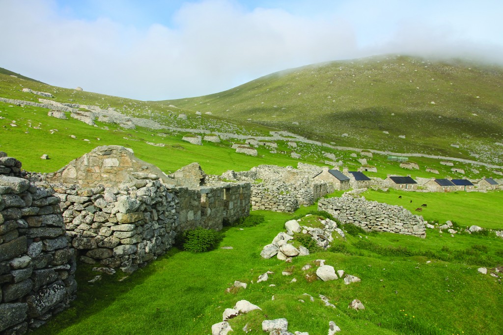
After the morning pea-soup fog lifted, we had a lovely sail and arrived at the tiny group of three islands, which was partly shrouded in fog, in the early afternoon. We immediately went ashore, which is not easy, even with very little swell. But there’s a ranger there and he gladly helped with the dinghy on the slippery steps to the old stone pier. The houses, a small church and the schoolroom, stand as they were left by the inhabitants, along with the ruins of even older houses. A couple of them have been re-roofed and one houses a small museum.
The main island, Hirta, had been inhabited for several thousand years, its inhabitants surviving by keeping goats and catching sea birds. Fishing was too difficult for more than the occasional catch. But in the thirties, tourists were starting to visit the island regularly, showing the young that there was an outside world and a group of them eventually emigrated to Australia, where there is now a suburb named St. Kilda near Melbourne. It was never easy keeping the population up, as the “eight day fever” claimed 80 percent of all newborn. This was due to a tradition of anointing the umbilical cord with fulmar oil, extracted from the local fulmars’ stomachs and kept in a wooden bowl.
The island is very stony and littered with the old “cleits”, which was used as small, stone storage sheds, as well as shelter if one was caught out in inclement weather. It can be very windy out there; sheep were sometimes blown right off the cliffs and into the ocean. In later times, a meteorological station was blown away after registering a wind speed of over 150 mph.
We had a nice, if slightly rolly, night at anchor and even got to go ashore again next morning. We left in the afternoon and motored over to the two adjoining islands, which are inhabited by millions of birds. The three islands, and two so-called stacks, are remains of a long extinct volcano. With the ever-present fog swirling about, the place had an eerie feel, but it was fantastic for bird watching.
Finally, we pointed the bow towards the mainland and had a lovely sail, arriving in bright sunshine in the early morning hours. We didn’t stop, but wound our way through the Sound of Lewis and aimed for The Shiant Isles, which lie between the Inner and Outer Hebrides. They are also of volcanic origin, with basalt columns showing here and there. We got escorted all the way, from the Sound of Lewis, by a pod of dolphins playing in our bow wave and then we were treated to thousands of puffins among the islands. What a magic ending of our trip to the Outer Hebrides.
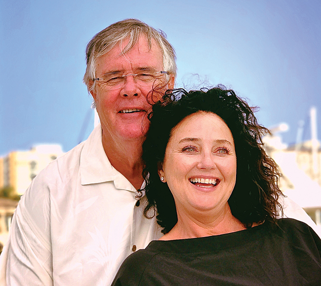
Looking specifically for a full keel cruising boat, Judith and her husband first chartered an Island Packet in the Caribbean. Then after visiting the factory they purchased Touché, their IP 380 in the UK. They currently reside in Denmark and are looking forward to a trans-Atlantic crossing.